8
GPSMAP 400/500 Series Installation Instructions
Connecting the Wiring Harness to a Garmin CANet Device
If your GPSMAP 400/500 series chartplotter is Garmin CANet-compatible, it can receive sonar information from a CANet-compatible Garmin
Sounder or Fishfinder device. See the chartplotter functionality matrix on
to determine whether your chartplotter is CANet compatible.
Using the CANet optimizes the performance of CANet-compatible devices, allowing sonar information from a sounder or fishfinder to be
shared with up to two CANet compatible Garmin chartplotters. A standard NMEA 0183 connection only allows depth, temperature, and speed
information to be sent to a single chartplotter, whereas a CANet connection provides full sonar readings, including Ultrascroll
™
, so you can
view and control the same information on your compatible chartplotter(s) as you can on your compatible Garmin sounder or fishfinder.
NOTE
: To use the Garmin CANet with your device, you must purchase an optional CANet Kit. Contact your Garmin dealer, or visit
.
Connecting the Chartplotter to a NMEA 2000 Network
If your GPSMAP 400/500 series chartplotter is NMEA 2000-compatible, you can connect it to an existing NMEA 2000 network on your boat
to share information with other connected NMEA 2000-compatible devices. If you do not have an existing NMEA 2000 network on your boat,
you will need to build one. See
NOTE
: NMEA 2000-compatible GPSMAP 400/500 series chartplotters are not packaged with NMEA 2000 connectors or cables. You will need
a NMEA 2000 T-connector and drop cable to connect it to an existing NMEA 2000 network. NMEA 2000 components are available from your
local Garmin dealer or marine dealer.
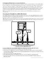
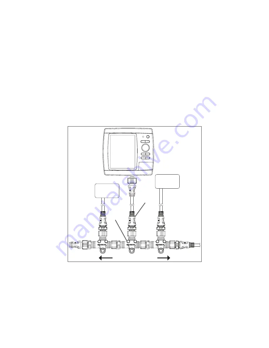
Connecting a NMEA 2000-compatible GPSMAP 400/500 Series
Chartplotter to an Existing NMEA 2000 Network
Existing NMEA 000 network
Drop cable
(not included)
T-connector
(not included)
NMEA 000
device
(not included)
NMEA 000
device
(not included)
NMEA 000-
compatible
GPSMAP
400/500 series
chartplotter
To connect a NMEA 2000-compatible GPSMAP 400/500 series chartplotter to your existing NMEA 2000 network:
1. Determine an appropriate location to connect the chartplotter to your existing NMEA 2000 network.
2. Disconnect one side of a NMEA 2000 T-connector from the backbone nearest to the location where you want to connect the chartplotter.
If you need to extend the NMEA 2000 backbone, connect an appropriate NMEA 2000 backbone extension cable (not included) to the side of
the T-connector you disconnected.
3. Add a T-connector (not included) to the NMEA 2000 backbone.
4. Route a NMEA 2000 drop cable from the chartplotter to the top of the T-connector you added to your NMEA 2000 network.
You can use a drop cable up to 20 ft. (6 m). If more cable is needed, add an extension to your NMEA 2000 backbone, based on the
NMEA 2000 guidelines.


