background image

2

Thread the other end of the strap through the loop, and pull it 

tight.

Device Care

NOTICE

Avoid chemical cleaners, solvents, and insect repellents that can 

damage plastic components and finishes.
Do not store the device where prolonged exposure to extreme 

temperatures can occur, because it can cause permanent 

damage.
The device is water resistant to IEC Standard 60529 IPX7. It can 

withstand accidental immersion in 1 meter of water for 30 

minutes. Prolonged submersion can cause damage to the 

device. After submersion, be certain to wipe dry and air dry the 

device before using or charging.
Thoroughly rinse the device with fresh water after exposure to 

chlorinated or salt water environments.

Cleaning the Device

NOTICE

Even small amounts of sweat or moisture can cause corrosion 

of the electrical contacts when connected to a charger. 

Corrosion can prevent charging and data transfer.

1

Wipe the device using a cloth dampened with a mild 

detergent solution.

2

Wipe it dry.

After cleaning, allow the device to dry completely.

Data Management

You can store files on your device. The device has a memory 

card slot for additional data storage.

NOTE: 

The device is compatible with Windows 7 and newer, 

and Mac OS 10.4 and newer.

File Types

The handheld device supports these file types.
• Files from BaseCamp or HomePort

. Go to 

www.garmin.com

/trip_planning

.

• GPX track files.
• GPX geocache files. Go to 

www.garmin.com/geocache

.

• GGZ geocache files. Go to 

www.garmin.com/geocache

.

• JPEG photo files.
• GPI custom POI files from the Garmin POI Loader. Go to 

www.garmin.com/products/poiloader

.

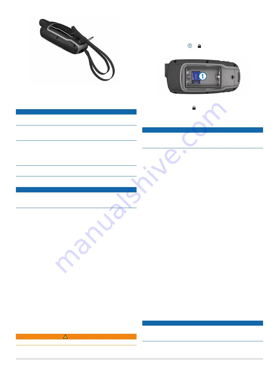
Installing a Memory Card

 WARNING

Do not use a sharp object to remove user-replaceable batteries.

You can install a microSD memory card in the handheld device 

for additional storage or pre-loaded maps.

1

Turn the D-ring counter-clockwise, and pull up to remove the 

cover.

2

Remove the batteries.

3

Slide the card holder   to   and lift up.

4

Place the memory card with the gold contacts facing down.

5

Close the card holder.

6

Slide the card holder to   to lock it.

7

Replace the batteries and cover.

Connecting the Device to Your Computer

NOTICE

To prevent corrosion, thoroughly dry the USB port, the weather 

cap, and the surrounding area before charging or connecting to 

a computer.

Before you can operate your device while connected to your 

computer, you must install batteries. The computer USB port 

may not provide enough power to operate the device.

1

Pull up the weather cap from the mini-USB port.

2

Plug the small end of the USB cable into the mini-USB port.

3

Plug the large end of the USB cable into a computer USB 

port.
On Windows computers, the device appears as a removable 

drive or a portable device, and the memory card may appear 

as a second removable drive. On Mac computers, the device 

and memory card appear as mounted volumes.

Transferring Files to Your Device

1

Connect the device to your computer.
On Windows computers, the device appears as a removable 

drive or a portable device, and the memory card may appear 

as a second removable drive. On Mac computers, the device 

and memory card appear as mounted volumes.

NOTE: 

Some computers with multiple network drives may not 

display device drives properly. See your operating system 

documentation to learn how to map the drive.

2

On your computer, open the file browser.

3

Select a file.

4

Select 

Edit

 > 

Copy

.

5

Open the portable device, drive, or volume for the device or 

memory card.

6

Browse to a folder.

7

Select 

Edit

 > 

Paste

.

The file appears in the list of files in the device memory or on 

the memory card.

Deleting Files

NOTICE

If you do not know the purpose of a file, do not delete it. Your 

device memory contains important system files that should not 

be deleted.

1

Open the 

Garmin

 drive or volume.

2

If necessary, open a folder or volume.

12

Device Information

Summary of Contents for GPSMAP 64X Series

Page 1: ...GPSMAP 64SERIES GPSMAP64X SERIES Owner sManual ...

Page 2: ...es BaseCamp chirp Garmin Connect Garmin Express HomePort and tempe are trademarks of Garmin Ltd or its subsidiaries These trademarks may not be used without the express permission of Garmin The Bluetooth word mark and logos are owned by the Bluetooth SIG Inc and any use of such marks by Garmin is under license Mac is a trademark of Apple Inc registered in the U S and other countries microSD and th...

Page 3: ...s 6 Downloading Geocaches Using a Computer 6 Navigating to a Geocache 6 chirp 6 Sending and Receiving Data Wirelessly 6 Setting a Proximity Alarm 6 Selecting a Profile 6 Area Calculation 6 Calculating the Size of an Area 6 Satellite Page 6 GPS Satellite Settings 6 Garmin Adventures 7 Sending Files to BaseCamp 7 Creating an Adventure 7 Starting an Adventure 7 VIRB Remote 7 Waypoint Averaging 7 Blue...

Page 4: ...Turning On the Backlight 13 Optional Accessories 13 tempe 13 Pairing Your ANT Sensors 13 Troubleshooting 13 Restarting the Device 13 Viewing Device Information 13 Restoring All Default Settings 13 Index 14 ii Table of Contents ...

Page 5: ...ons Maximizing Battery Life You can do several things to extend the life of the batteries Reduce the backlight brightness Adjusting the Backlight Brightness page 9 Reduce the backlight timeout Display Settings page 9 Use battery save mode Turning On Battery Save Mode page 1 Decrease the map drawing speed Map Settings page 3 Turn off GLONASS or GALILEO GPS and Other Satellite Systems page 9 Turning...

Page 6: ... D ring clockwise 4 Hold 5 Select Setup System AA Battery Type 6 Select Alkaline Lithium Traditional NiMH or Precharged NiMH Turning On the Device Hold Keys FIND Select to open the search menu MARK Select to save your current location as a waypoint QUIT Select to cancel or return to the previous menu or page Select to scroll through the main pages ENTER Select to select options and acknowledge mes...

Page 7: ...mpass You can use the compass to navigate an active route 1 Select PAGE 2 Hold the device level 3 Follow to your destination Course Pointer The course pointer is most useful when you are navigating on water or where there are no major obstacles in your path It can also help you avoid hazards near the course such as shoals or submerged rocks To enable the course pointer from the compass select MENU...

Page 8: ...oing or where you have been You can add details about the location such as name elevation and depth You can add a gpx file that contains waypoints by transferring the file to the GPX folder Transferring Files to Your Device page 12 Creating a Waypoint You can save your current location as a waypoint 1 Select MARK 2 If necessary select a field to make changes to the waypoint 3 Select Done Projectin...

Page 9: ... Current Track Select Track Manager Current Track Clear Current Track Deleting a Track 1 Select Track Manager 2 Select a track 3 Select Delete Navigating a Saved Track 1 Select FIND Tracks 2 Select a saved track 3 Select Go Purchasing Additional Maps 1 Go to your device product page at www garmin com 2 Click the Maps tab 3 Follow the on screen instructions Finding an Address You can use optional C...

Page 10: ...option To stop logging select Done To begin navigation to the geocache nearest you select Find Next Closest To enter a comment about looking for the cache or about the cache itself select Add Comment enter a comment and select Done If you are signed in to www geocaching com the log uploads to your www geocaching com account automatically chirp A chirp is a small Garmin accessory that is programmed...

Page 11: ...end an adventure from BaseCamp to your device Sending Files to BaseCamp page 7 1 Select Adventures 2 Select an adventure 3 Select Start VIRB Remote NOTE The VIRB Remote feature is available only with GPSMAP 64s sc st sx csx devices Before you can use the VIRB Remote function you must enable the remote setting on your VIRB camera The VIRB Remote function allows you to control your VIRB camera from ...

Page 12: ...pth The depth of the water Your device must be connected to a NMEA 0183 or NMEA 2000 device capable of acquiring the water depth Descent Average The average vertical distance of descent since the last reset Descent Maximum The maximum rate of descent in feet per minute or meters per minute since the last reset Descent Total The total elevation distance descended since the last reset Distance To De...

Page 13: ... a predetermined altitude You must be navigating for this data to appear Waypoint At Dest The last point on the route to the destination You must be navigating for this data to appear Waypoint At Next The next point on the route You must be navigating for this data to appear System Settings Select Setup System Satellite System Sets the satellite system to GPS GPS GLONASS GPS GALILEOor Demo Mode GP...

Page 14: ... item to reset Changing the Page Sequence 1 Select Setup Page Sequence 2 Select a page 3 Select Move 4 Move the page up or down in the list 5 Select ENTER TIP You can select PAGE to view the page sequence Adding a Page 1 Select Setup Page Sequence 2 Select Add Page 3 Select a page to add Removing a Page 1 Select Setup Page Sequence 2 Select a page 3 Select Remove 4 Select ENTER Customizing the Mai...

Page 15: ...s of measurement the changes are saved automatically as part of the profile Creating a Custom Profile You can customize your settings and data fields for a particular activity or trip 1 Select Setup Profiles Create Profile OK 2 Customize your settings and data fields Editing a Profile Name 1 Select Setup Profiles 2 Select a profile 3 Select Edit Name 4 Enter the new name Deleting a Profile NOTE Be...

Page 16: ...ng counter clockwise and pull up to remove the cover 2 Remove the batteries 3 Slide the card holder to and lift up 4 Place the memory card with the gold contacts facing down 5 Close the card holder 6 Slide the card holder to to lock it 7 Replace the batteries and cover Connecting the Device to Your Computer NOTICE To prevent corrosion thoroughly dry the USB port the weather cap and the surrounding...

Page 17: ...or to a secure strap or loop where it is exposed to ambient air and therefore provides a consistent source of accurate temperature data You must pair the tempe with your device to display temperature data from the tempe Pairing Your ANT Sensors Before you can pair you must put on the heart rate monitor or install the sensor The device is compatible with the heart rate monitor GSC 10 speed and cade...

Page 18: ...zoom 3 marine alarms setup 10 settings 10 measuring distances 3 memory card 12 microSD card See memory card N navigating 3 navigation 3 stopping 5 notifications 7 8 P pairing ANT sensors 13 smartphone 7 photos 5 6 taking 5 viewing 5 6 position format 10 power key 2 product registration 11 profiles 6 11 proximity alarms 6 R registering the device 11 resetting the device 10 restoring settings 13 rou...

Page 19: ......

Page 20: ...support garmin com May 2019 190 01702 00_0D ...

Reviews: