You should test the DVI cable by connecting the devices
before routing the cable.
Card Reader Connections
Connecting to Power
WARNING
When connecting the power cable, do not remove the in-line
fuse holder. To prevent the possibility of injury or product
damage caused by fire or overheating, the appropriate fuse
must be in place as indicated in the product specifications. In
addition, connecting the power cable without the appropriate
fuse in place will void the product warranty.
1
Route the power cable to the power source and to the
device.
2
Connect the red wire to the positive (+) battery terminal, and
connect the black wire to the negative (-) battery terminal.
3
Install the locking ring and o-ring on the end of the power
cable.
4
Connect the power cable to the device by turning the locking
ring clockwise.
Connecting the Card Reader to the Garmin Marine
Network
The card reader is not compatible with Garmin chartplotters
prior to the GPSMAP 8000 Series and GPSMAP 8500.
Connect the card reader to a Garmin device on the Garmin
Marine Network using a Garmin Marine Network cable.
Data from cards inserted in the card reader is shared with all
compatible devices on the Garmin Marine Network.
Updating the Device Software
The device may contain a software-update memory card. If so,
follow the instructions provided with the card.
If a software update memory card is not included, go to
to make sure your device software is up-to-
date.
1
If necessary, load the software update onto the memory card
from your computer by following the instructions on
2
Turn on the chartplotter.
3
Insert the memory card into the card slot.
4
Follow the on-screen instructions.
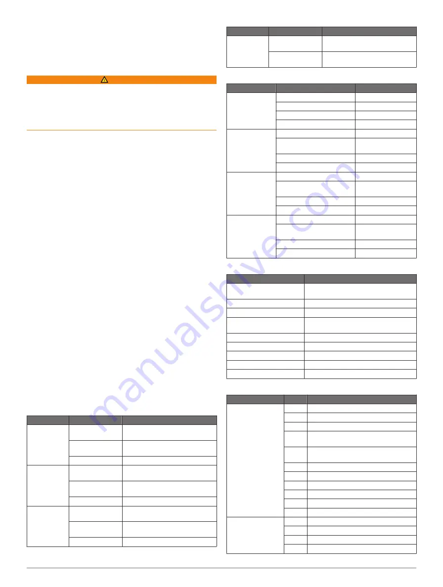
Specifications
Physical Specifications
Device
Specification
Measurement
Eight-inch
models
Dimensions
(W×H×D)
10
7
/
16
× 7
31
/
64
× 4
17
/
32
in. (265 ×
190 × 115 mm)
Display size
(W×H)
6
47
/
64
in. × 5
1
/
8
in. (171 × 130 mm)
Weight
7.12 lbs (3.23 kg)
Twelve-inch
models
Dimensions
(W×H×D)
13
7
/
64
× 9
23
/
32
× 3
13
/
36
in. (333 ×
247 × 97 mm)
Display size
(W×H)
9
21
/
32
in. × 7¼ in. (245 × 184 mm)
Weight
10.91 lbs (4.95 kg)
Fifteen-inch
models
Dimensions
(W×H×D)
15
7
/
8
× 12
3
/
64
× 3
45
/
64
in. (403 ×
306 × 94 mm)
Display size
(W×H)
11
31
/
32
in. × 8
63
/
64
in. (304 × 228
mm)
Weight
16.76 lbs (7.6 kg)
Device
Specification
Measurement
All models
Temperature
range
From 5° to 131°F (from -15° to
55°C)
Material
Die case aluminum and
polycarbonate plastic
Power Specifications
Device
Specification
Measurement
All models
Input power
10–35 Vdc
Fuse
7.5 A, 42 V fast-acting
NMEA 2000 LEN
2
NMEA 2000 Draw
75 mA max.
Eight-inch
models
Max. power usage at 10 Vdc 28 W
Typical current draw at 12
Vdc
1.3 A
Max current draw at 12 Vdc
2.8 A
Compass-safe distance
12
13
/
64
(310 mm)
Twelve-inch
models
Max. power usage at 10 Vdc 35 W
Typical current draw at 12
Vdc
1.6 A
Max. current draw at 12 Vdc 3.5 A
Compass-safe distance
18
7
/
64
(460 mm)
Fifteen-inch
models
Max. power usage at 10 Vdc 47 W
Typical current draw at 12
Vdc
2.5 A
Max. current draw at 12 Vdc 4.7 A
Compass-safe distance
18
7
/
64
(460 mm)
GPS 19x Antenna Specifications
Measurement
Specification
Dimensions (diameter x
height)
3
19
/
32
in. × 1
15
/
16
in. (91.6 × 49.5 mm)
Weight
7.1 oz (201 g)
Temperature range
-22° to 176°F (-30° to 80°C)
Case material
Fully gasketed, high-impact plastic alloy,
waterproof to IEC 60529 IPX7 standards.
Compass-safe distance
5
57
/
64
in. (150 mm)
Power input source
9–16 Vdc
Input current
40 mA at 12 Vdc
NMEA 2000 LEN
2
NMEA 2000 draw
100 mA max
NMEA 2000 PGN Information
Type
PGN
Description
Transmit and
receive
059392 ISO acknowledgment
059904 ISO request
060928 ISO address claim
126208 NMEA: Command, request, and
acknowledge group function
126464 Transmit and receive PGN list group
function
126996 Product information
129026 COG and SOG : Rapid update
129029 GNSS position data
129540 GNSS satellites in view
130306 Wind data
130312 Temperature
Transmit
127250 Vessel heading
127258 Magnetic variance
128259 Speed: Water referenced
128267 Water depth
12


