8-4
GTN 625/635/650 Pilot’s Guide
190-01004-03 Rev. P
Map
8.1.1
Map Overlays
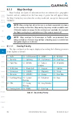
Map Overlays are layers of information that are referenced to geographic
location and are overlayed on the base map. A green bar will appear below
the Map Overlay key text when the overlay is selected, except for Airways and
NEXRAD.
NOTE
: Map overlay keys do not turn on or activate equipment necessary
for the overlay to function. Map overlay keys may remain available even
if the information necessary for the overlay is not available. For example:
the Radar overlay key is available even if the radar is turned off.
NOTE
: Map overlays for Stormscope or Traffic are prevented from
being overlaid on the main map without a heading source or while User
Navigation Angles are selected.
8.1.1.1
Overlay Priority
The data overlayed on the map is displayed according the following priorities
(from highest to lowest):
1 - Traffic
10 - Cell Movement 19 - AIREPS
28 - NEXRAD
2 - Ownship
11 - Lightning
20 - City Forecast
29- Cloud Tops
3 - Flight Plan
12 - METARs
21 - Surface
Analysis
30 - IR Satellite
4 - TAWS Alerts
13 - Winds Aloft
22 - Airspace
31 - SafeTaxi
5 - Stormscope
14 - SIGMETs
23 - Waypoints
32 - Terrain
6 - Obstacles
15 - AIRMETs
24 - Airways
33 - Base Map
7 - Fuel Range Ring 16 - Cyclone
Warning
25 - Turbulence
34 - Topo
8 - TFRs
17 - County
Warning
26 - Icing Potential
9 - Freezing Levels
18 - PIREPs
27 - Echo Tops
Table 8-1 Data Overlay Priority
Summary of Contents for GTN 625
Page 608: ...This page intentionally left blank ...
Page 609: ......
Page 610: ...190 01004 03 Rev P ...

