11-52
GTN 625/635/650 Pilot’s Guide
190-01004-03 Rev. P
Weather
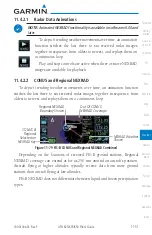
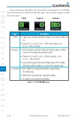
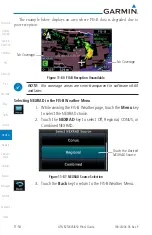
Source options are selectable from the weather setup menu or the NEXRAD
key at the bottom left of the FIS-B Weather page. The key label changes to reflect
the active source.
CONUS
Regional
Combined
Type
Description
CONUS
• Large, low-resolution weather image for the entire continental
U.S.
• Pixels are 7.5 min (7.5 nm = 13.89 km) wide by 5 min
(5 nm = 9.26 km) wide
Regional
• High-resolution weather image with limited range, centered
around each broadcasting ground station
• Pixels are 1.5 min (1.5 nm = 2.78 km) wide by 1 min
(1 nm = 1.852 km) tall
• Each weather pixel varies with latitude. Above 60º latitude,
pixel block width doubles to 3 min/nm for regional maps
Combined
• Both CONUS and Regional NEXRAD images display
simultaneously
• White hash mark indicates regional boundary
• Animation functionality not available
Table 11-4 FIS-B NEXRAD Types
Summary of Contents for GTN 625
Page 608: ...This page intentionally left blank ...
Page 609: ......
Page 610: ...190 01004 03 Rev P ...


