1-21
190-01004-03 Rev. P
GTN 625/635/650 Pilot’s Guide
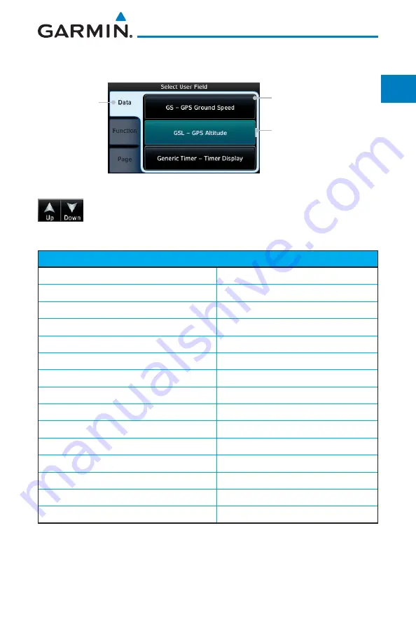
4. Touch the
Data, Function,
or
Page
information types.
Field Type List
Touch to Select
Data Field
Selected Field
Type
Slider Indicates More
Selections Available
Press Finger and Slide to
View More Selections
Figure 1-25 Map Data Field Type Selections
5. Touch the
Up
or
Down
keys or touch the display and drag
your finger to scroll through the list. Touch the desired item
to select it or touch the
Back
key to cancel selection.
Data Field Type
ACTV WPT - Active Waypoint
MSA - Minimum Safe Altitude
B/D APT - BRG/DIS from Dest APT
1
NAV/COM - Active NAV/COM FREQ
BRG - Bearing to Current Waypoint
OAT (static) - Static Air Temperature
DIS - Distance to Current Waypoint
OAT (total) - Total Air Temperature
DIS to Dest - Distance to Destination
2
RAD ALT - Radar Altimeter
DTK - Desired Track
Time - Current Time
ESA - Enroute Safe Altitude
Time to TOD - Time to Top of Descent
ETA - Estimated Time of Arrival
TKE - Track Angle Error
ETA at Dest - ETA at Destination
TRK - Track
ETE - Estimated Time Enroute
Trip Timer - Timer Display
ETE to Dest - ETE to Destination
VOR/LOC - Tuned VOR/LOC Info
Fuel Flow - Total Fuel Flow
VSR - Vertical Speed Required
GS - GPS Ground Speed
Wind - Wind Speed and Direction
GSL - GPS Altitude
XTK - Cross Track Error
Generic Timer - Timer Display
OFF - Do Not Display Data Field
Table 1-1 Data Field Types of Information
Note 1:
B/D APT is the straight line distance.
Note 2:
Dist to DEST is the distance along the flight plan.
Summary of Contents for GTN 625
Page 608: ...This page intentionally left blank ...
Page 609: ......
Page 610: ...190 01004 03 Rev P ...


