Using the Graphic Map
Understanding the Graphic Map
The Graphic Map is nRoute's main navigation tool. nRoute displays the basemap and any detailed maps you
select in MapSource. The basemap contains major cities, roads, and highways, while detailed maps contain
smaller streets, addresses, intersections, and Points of Interest.
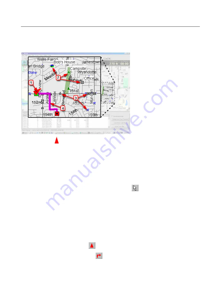
1. The Vessel icon indicates your position and heading on the Graphic Map.
2. Waypoints are displayed by symbol and by name.
3. Points of Interest are displayed as symbols. The names of some Points of Interest are displayed on the
map in a different font than waypoint names.
4. Active routes are displayed as colored lines on the map. The beginning point of the route is green; the
ending point of the route is red.
Graphic Map Tips
•
To view the name of a Point of Interest, click the
Selection Tool
, then hold the mouse cursor over the
desired Point of Interest on the map.
•
If multiple items are displayed at a single location on the Graphic Map, right-click on the location, then
select the desired item from the list that appears.
•
You can perform a variety of tasks by right-clicking on the Graphic Map. See Map Feature Right-Click
Menu for more information.
•
The Information Tabs across the bottom of the screen show waypoints, routes, and tracks. To display an
item on the Graphic Map, right-click on the item in the appropriate Information Tab and select
Show
Selected Item on Map
.
•
Click the
Keep Vessel Visible
button
to center the Vessel icon on the map.
•
Click the
Keep Maneuver Visible
button
to show the next maneuver on the map while you are
navigating on a route.
15
Summary of Contents for nRoute
Page 1: ...nRoute GPS navigation software help contents...
Page 32: ...Legend of Map Symbols Legend Businesses and Attractions 30...
Page 33: ...Legend Points of Interest 31...
Page 34: ...Legend Map Lines 32...
Page 35: ...Legend Map Areas 33...
Page 41: ...39...
Page 43: ...41...
Page 82: ...7 Click Close to exit the Vertical Profile window 80...
Page 129: ......


