1
Pr
eliminary
Main Pages
Features
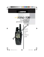
Rino 130 - Overview
The Rino 130 (
R
adios
I
ntegrated with
N
avigation for
the
O
utdoors) is a 7.6 ounce, 12 channel GPS-enabled
handheld device with integrate radio functionality to pro-
vide two-way communications for up to two miles using
14 FRS (Family Radio Service) and 8 high-performance
GMRS (General Mobile Radio Service) channels for up to
fi ve miles. You can keep track of up to 50 other contacts
from other Rino users.
The Rino 130 has seven keys located on the unit that
allow the user to quickly access all of the units functions.
The Rino 130 has a 160 X 160 pixel, 4 level gray mono-
chrome display for easy viewing.
The Rino can store up to 500 waypoints with a 10-
character name and graphic symbol. The active track log
will store up to 3000 points and allow you to save up to
20 tracks with 250 points per track.
Built-in cartography of a North American base map
that includes Interstate and State Highways and Exit
Information. Using MapSource™, Garmin’s map data
software (not included), you could choose to have the
Rino 130 display up to 8MB of a variety of different
map information. We currently offer several mapping
options that are compatible with the Rino 130 includ-
ing our MetroGuide, Topo, Fishing Hot Spots, and
BlueChart data. Check your local dealer or our web site
(www.Garmin.com) for a complete listing of MapSource
products.
Garmin designed your Rino 130 with the user in
mind. The Rino 130 is waterproof to IPX7 standards and
is rugged enough to endure the most trying use, and
Garmin’s friendly user interface will allow you to start
navigating with your new GPS in no time. Your Rino 130
can provide one more critical benefi t, peace of mind.
With your Rino 130 you will know where you are, where
you’ve been and where you’re going. And since you’ll
always know the way back home, you can concentrate on
what you set out to do, explore the great outdoors.
190-00284-00_Prelim_FCC.indd 1
9/18/2003, 3:50:45 PM


