iSXblue/SXBlue II GNSS Series Technical Reference Manual
162
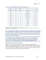
Table C-1 Worldwide SBAS Constellation (December 2012)
SBAS
Constellation
PRN
Number
NMEA
Number
Satellite Name
Longitude
WAAS
133
46
Inmarsat 4F3
98.0° W
WASS
135
48
Galaxy XV
133.0 W
WAAS
138
51
Anik F1R (Telesat)
107.3° W
EGNOS
120
33
Inmarsat 3F2 (AOR-E)
15.5° W
EGNOS
124
37
ESA (Artemis)*
21.5° E*
EGNOS
126
39
Inmarsat 3F5 (IND-W)
25.0° E
MSAS
129
42
MTSAT 1R
140.0° E
MSAS
137
50
MTSAT 2
145.0° E
GAGAN
127
40
GSAT-8
55.0° E
GAGAN
128
41
GSAT-10
83.0° E
SDCM
125
38
Luch-5B**
16.0° W**
SDCM
140
53
Luch-5V**
95.0° E**
SDCM
141
54
Luch-5A**
167.0° E**
* EGNOS PRN 124 normally used to perform industry tests, is currently set to test mode.
** SDCM is not operational. Luch-5B might be repositioned to a more eastern location. Luch-5A is currently at 95.0°E and will be moved to
167.0°E. Luch-5V launch is planned for Q1 2014.
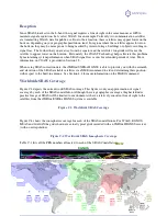
Note - The satellite elevation angle lowers with increasing distance away from the equator and from
the satellite’s longitude. Although a good amount of signal coverage is shown in Northern latitudes
for both WAAS and EGNOS, it may not be usable due to its low elevation angle and the potential
for it to be obstructed. Ideally, testing of the system in the area of its use is recommended to ensure
that the signal is sufficiently available.
Note - The SBAS signal coverage may be present in some areas without either sufficient ionospheric
map coverage or satellites with valid orbit and clock correctors. In such a case, differential
positioning with SBAS may not be desirable or possible, as four or greater satellites (with
correctors) must be available to compute a DGPS position. The next section provides further
information on the ionospheric map features of SBAS and the iSXBlue/SXBlue II GNSS.
SBAS Ionospheric Map Extrapolation
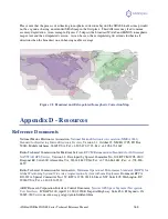
To improve upon the ionospheric map provided by SBAS, the iSXBlue/SXBlue II GNSS receiver
extrapolates a larger ionospheric map from the broadcast coverage map, extending its effective coverage.
This allows the iSXBlue/SXBlue II GNSS to be used successfully in regions where competitive products
may not. For example, the extrapolation provides enhanced coverage through the northern part of South
America for WAAS, through the northern part of Africa for EGNOS, etc.

