Section 7 IFR Procedures
1
st
Ed Nov 2018
IDU-450 EFIS Software Version 8.0H (Rotorcraft)
7-11
failure), skyway boxes disappear after one minute to indicate degraded
navigation performance.
Skyway box altitude is controlled by VNAV altitude, aircraft altitude, aircraft
climb performance, and climb/descent angle setting. If no VNAV altitude is
set, the skyway boxes describe the desired lateral flight path of the aircraft
at the aircraft's current altitude.
With a VNAV altitude set, the boxes provide both lateral and vertical
guidance. Climb and descent angle settings are controlled individually with
a resolution of 0.1°. VNAV is guided by VNAV waypoints determined by
VNAV altitude and VNAV offset from flight plan waypoints. There are two
sources for VNAV altitudes, the navigation database and manual input
through the ACTV menu, which are computed automatically by the system
using “look-ahead” rules. When “look-ahead” finds a further VNAV altitude
constraint above the previous VNAV altitude constraint (i.e., climb
commanded), an automatic VNAV altitude is continuously calculated for the
waypoint based upon an immediate climb to the altitude constraint at the
higher of actual climb angle or the climb angle setting (dynamic climb
angle). When “look-ahead” finds a further VNAV altitude constraint below
the previous VNAV altitude constraint (i.e., descent commanded), an
automatic VNAV altitude is calculated for the waypoint based on a descent
to reach the VNAV altitude constraint at the associated waypoint using the
descent angle setting. If no further VNAV altitude constraints are found, the
automatic VNAV altitude is set to the last valid VNAV altitude constraint.
When a VNAV climb is desired, the boxes are drawn at a vertical position
the higher of: (a) the dynamic climb angle emanating from the aircraft's
present position (aircraft-referenced); (b) the dynamic climb angle
emanating from the next waypoint VNAV altitude (geo-referenced forward);
or (c) the climb angle setting emanating from the previous waypoint VNAV
altitude (geo-referenced backward). The geo-referenced backward
calculation is only considered when the current leg is part of a procedure
and is designed to provide pilot awareness, if a specified climb gradient is
not being met. Once the boxes intercept the VNAV altitude, further boxes
are drawn with a zero angle to show a level off followed by a level flight
segment as an anticipatory cue for planning. Climb guidance is depicted in
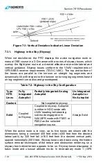
Figure 7-4, Figure 7-5, and Figure 7-6.

