Section 3 Display Symbology
1
st
Ed Nov 2018
IDU-450 EFIS Software Version 8.0H (Rotorcraft)
3-21
Obstructions within the following ranges are depicted on the PFD in SVS
Basic or SVS TAWS modes:
1) Narrow FOV: 17NM
2) Wide FOV: 12NM
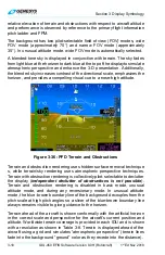
Obstructions such as towers, antennas, buildings, and other manmade
structures are shown on the PFD display as vertical amber (yellow) lines
(see Figure 3-38). They are conformal in location and size and only shown
in conjunction with terrain regardless of altitude. Obstructions representing
a collision hazard are annunciated aurally and with a caution or warning
flag. See Section 2 System Overview for description of alerts when
obstructions represent a collision hazard.
WARNING:
MANY TOWERS, ANTENNAS, STRUCTURES, AND OBSTRUCTIONS
ARE NOT IN THE DATABASE.
NOTE:
The obstruction data is provided by Jeppesen and must be updated each
28 days to maintain current database information.
Obstructions without Hazardous
Condition
Obstructions Creating an
OBSTRUCTION Warning
Figure 3-38: PFD with Obstructions

