Section 7 IFR Procedures
7-10
IDU-450 EFIS Software Version 8.0H (Rotorcraft)
1
st
Ed Nov 2018
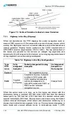
Figure 7-3: Vertical Deviation Indicator Linear Deviation
7.3.1. Highway in the Sky (Skyway)
When not decluttered, the PFD displays the active navigation route or
manual OBS course in a 3-D manner with a series of skyway boxes, which
overlay the flight plan route at a desired altitude and provide lateral and
vertical guidance. Skyway boxes conform to the VNAV requirements of
GPS/SBAS receiver requirements (TSO-C-146C). The top and bottom of
the boxes are parallel to the horizon on straight leg segments and
dynamically tilt with respect to the horizon on turning leg segments based
on leg-segment turn radius and groundspeed.
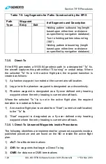
Table 7-2: Highway in the Sky Configuration
Type
HITS
Lines
Fully
Integrated
Autopilot
Partially Integrated Analog
Autopilot
Un-Integrated
Autopilot or
No Autopilot
Dashed
Not coupled to skyway
Solid
Coupled
to Skyway
Coupled to skyway. Autopilot
is either in HDG mode with
LNAV heading/roll-steering
sub-mode engaged or in
NAV/APR mode with FMS1 or
FMS2 as the selected
navigation source.
Always Solid
When the active route is in view, up to five boxes are shown with the
dimensions being a constant 400 feet wide (±200 feet from the desired
lateral path) by 320 feet tall (±160 feet from the desired vertical path)
spaced horizontally 2000 feet. Skyway boxes are drawn using the hidden
surface removal techniques of the terrain and obstruction rendering, so a
skyway box behind terrain appears to be so. Skyway boxes disappear in
basic mode and unusual attitude mode. In reversionary mode 1 (GPS

