Traffic
1
st
Ed Nov 2018
IDU-450 EFIS Software Version 8.0H (Rotorcraft)
T-5
T 4.2. Traffic Page Screen Range
The following traffic screen selected ranges are available (all distances
represent the distance from the ownship symbol to the compass rose):
5NM, 10NM, and 20NM. A TCAS range ring is centered upon the ownship
symbol to help the pilot judge range to displayed symbols with a 3NM radius
in 5NM and 10NM ranges, has a radius of half the range in 20NM, 50NM,
and 100NM ranges, and is presented on the TCAS range ring (e.g., 3NM,
10NM, 25NM, or 50NM).
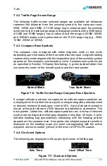
T 4.3. Compass Rose Symbols
The compass rose is aligned with either magnetic north or true north
depending upon the status of the true north discrete input. A digital heading
readout and pointer aligned with the longitudinal axis of the ownship symbol
appears on the compass rose boundary circle. Compass rose symbols are
as specified in Section 3 Display Symbology. A green dashed lubber line
connects the center of the aircraft symbol and the track pointer.
Normal Mode
True North Mode
Figure T-6: Traffic Screen Range Compass Rose Symbols
If a target altitude is set and not captured, an altitude capture predictor arc
is displayed on the lubber line at a point corresponding with predicted climb
or descent distance (based upon current VSI). A top of descent symbol is
shown at the point where a VNAV descent is predicted to commence. The
track pointer, lubber line, altitude capture predictor arc, and top of descent
symbol are not displayed when groundspeed is less than 30 knots. A pilot-
settable heading bug geometrically interacting with the heading pointer
appears on the compass rose. A magenta, star-shaped waypoint pointer is
displayed on the heading scale at a point corresponding with the active
waypoint and turns amber (yellow) in the event of GPS LON caution.
T 4.4. Clock and Options
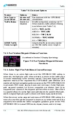
The following are displayed in the upper right corner of traffic page.
Zulu Time
Local Offset Time
Figure T-7: Clock and Options

