Section 8 Terrain Awareness Warning System
8-24
IDU-680 EFIS Software Version 8.0E (Fixed Wing)
Rev A Nov, 2016
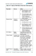
Table 8-11: Airplane TAWS Basic Parameters Determination
Parameter
Source
Notes
2) Otherwise, if the aircraft
is in
TERMINAL
mode,
reporting station
elevation is the elevation
of the airport causing
TERMINAL
mode.
3) In
ENROUTE
mode, no
reporting station
elevation is determined.
In the case of GPS/SBAS
geodetic height-based
barometric setting, reporting
station elevation is the GPS
MSL altitude reported at the
time the barometric setting
was determined.
QFE
: Barometric setting
resulting in the altimeter
displaying height above a
reference elevation (e.g.,
airport or runway threshold).
QNE
: Standard barometric
setting (29.92 inHg or 1013
mbar) used to display
pressure altitude for flight
above the transition altitude.
QNH
: Barometric setting
resulting in the altimeter
displaying altitude above
mean sea level at the
reporting station.
Terrain Data
Terrain
Database
To be considered valid, the
following must apply:
1) Aircraft position is valid;
Summary of Contents for IDU-680
Page 1: ......
Page 445: ...Traffic Rev A Nov 2016 IDU 680 EFIS Software Version 8 0E Fixed Wing T 1 Traffic...
Page 510: ...Datalink Rev A Nov 2016 IDU 680 EFIS Software Version 8 0E Fixed Wing D 1 Datalink...
Page 532: ...Weather Radar Rev A Nov 2016 IDU 680 EFIS Software Version 8 0E Fixed Wing WX 1 Weather Radar...
Page 547: ...Video Rev A Nov 2016 IDU 680 EFIS Software Version 8 0E Fixed Wing V 1 Video...

