Even though it is much more useful to have tracking done live, the GO4v3 product
line supports downloading data without the use of a cellular or paid for link. The data is
buffered and stored in the vehicle for the entire day's journey for a vehicle and then
downloaded through a downloader located at the customer's offices. The range of this
downloading varies but is typically 1000 ft. The downloaders are connected to an
Ethernet network and configured using Geotab.
Mobile support
Geotab supports most modern smartphones such as iOS, Andrioid and BlackBerry. Our
maps have been optimized for touch interaction and support panning, zooming and taps.
Upgrading from previous versions
Upgrading from a previous version of Geotab to 5.6 is mostly an automatic process.
There are some major improvements to some features in version 5.6 which add manual
steps that you may need to perform if you have some more advanced configurations.
Please read the next few sub-sections carefully to check whether you will need to perform
additional configuration after upgrading.
Generic engine rules
As of the July 2012 firmware update for Geotab GO Devices, the vehicle will now use a
generic engine ruleset for engine diagnostics. Previously, diagnostics were specific to
every type of engine source, for example, fuel level for both J1708 and J1939. Now,
there are generic and aggregated diagnostics which makes creating rules and generating
reports for a fleet with multiple engine types much easier.
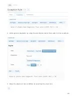
Exception rules created with specific engine types will no longer create exceptions after
the firmware has been upgraded. Follow these steps to re-enable exception reporting.
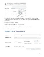
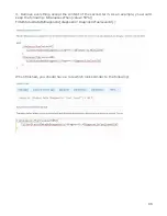
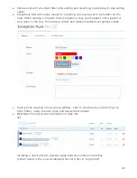
1. Check whether any rules on our account utilize an engine type (if they have a name
with an engine source type in parentheses as shown below)
84

