3
Note – Temperature and humidity
• In terms of accuracy, the temperature and air humidity
measurement is intended for private, non-commercial
use.
• In individual cases, the measured values displayed
may differ slightly from comparison values, e.g. values
from a calibrated measuring device. Using the Basic
and manual settings, you can adjust and recalibrate
the values for the room/outdoor temperature and/or
the humidity.
• We recommend that you do not manually calibrate
the measured values, press the
SET
button (28) during
manual setup to skip this step.
Note – Atmospheric pressure
• The absolute atmospheric pressure (
abs
) is a value
measured at the installation location that cannot be
changed.
• The relative atmospheric pressure (
rel
) is the absolute
atmospheric pressure at the installation location
corrected to the atmospheric pressure at sea level (msl).
• The reference value for relative atmospheric pressure
is set to 1013.2 hPa as standard. For an exact
measurement, adapt the reference value to your
location. You can manually set the reference value to
within a range of 919.0 hPa and 1080.0 hPa.
• Information on the current relative atmospheric pressure
for you location is available on the Internet, from your
local meteorological office, on the radio, etc.
Note – Atmospheric pressure threshold
value
• The weather forecast is based on atmospheric pressure
changes, and you individually set their threshold values
between 2 hPa and 4 hPa. The threshold value is set to
3 hPA as standard.
• A decrease or increase in the atmospheric pressure by
at least the set threshold value is registered as a change
in the weather.
• For locations with frequent changes in atmospheric
pressure, we recommend you set a higher atmospheric
threshold value than for locations with a relatively
constant atmospheric pressure.
Note – Storm threshold value
• The storm forecast is also based on atmospheric
pressure changes, and you individually set their
threshold values between 3 hPa and 9 hPa. The
threshold value is set to 6 hPA as standard.
• The storm warning display is activated if, over a period
of three hours, there is a decrease or increase in the
atmospheric pressure by at least the set threshold value.
• When the storm warning display is activated, the rain
symbol and the trend arrow flash for three hours.
6.3. Weather forecast
• Based on changes in the atmospheric pressure and the
data saved, the base station is able to make weather
forecasts for the next 12 to 24 hours.
Note – Weather forecast
• The weather forecast function is not available during
the first few hours of operation because it requires data
that is collected during operation.
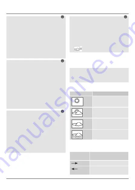
• The weather forecast and the current weather are indicated
by four different symbols (1):
Symbol (1)
Weather
Sun
Slightly cloudy
Cloudy
Rain
• Based on the measured barometer values, the atmospheric
pressure trend for the next few hours is displayed between
the weather forecast symbols.
Display (3)
Atmospheric pressure trend /
weather forecast
Increasing / Weather is improving
Decreasing / Weather is getting
worse
Summary of Contents for EWS-800
Page 2: ...A B 25 43 5 1 REMOTE SENSOR RF WIRELESS C Ch 36 37...
Page 34: ...31 4 4 1 38 38 4 2 34 5 6 100 1 25 4...
Page 35: ...32 5 1 35 33 5 2 33 39 6 MIN MAX 30 31 SNOOZE LIGHT 32 10 6 1 3 12 14 18 20 DCF 27 DCF 2 DCF...
Page 58: ...55 4 4 1 38 38 4 2 34 AA 5 6 100m 1 25 m 4...
Page 63: ...60 SNOOZE LIGHT 32 20 WLAN 7 8 Hama GmbH Co KG...
Page 125: ...122 4 4 1 38 AAA 38 4 2 34 AA 5 Montage 6 100 1 25 4...
Page 126: ...123 5 1 5 2 33 39 6 MIN MAX 30 31 SNOOZE LIGHT 32 10 6 1 LCD 3 12 14 18 20 DCF 27 DCF DCF DCF...
Page 128: ...125 2 hPa 4 hPa 3 hPA 3 hPa 9 hPa 6 hPa 6 3 12 24 1 1 3 3 3...


