


USING THE MAP . . . . . . . . . . . . . . . . . . . . . . . . . . . . . . . . . . . . . . . .1-23
Map Data Interrogation . . . . . . . . . . . . . . . . . . . . . . . . . . . . . . . . .1-24
Airport Information . . . . . . . . . . . . . . . . . . . . . . . . . . . . . . . . . . . .1-25
Navaid Information . . . . . . . . . . . . . . . . . . . . . . . . . . . . . . . . . . . .1-27
Airspace Interrogation . . . . . . . . . . . . . . . . . . . . . . . . . . . . . . . . .1-28
Airspace Alerting . . . . . . . . . . . . . . . . . . . . . . . . . . . . . . . . . . . . .1-29
Display Flight Plan Data on Map . . . . . . . . . . . . . . . . . . . . . . . . . .1-33
Temporarily Decluttering the Map . . . . . . . . . . . . . . . . . . . . . . . .1-34
Find Nearest (Units Without Internal GPS) . . . . . . . . . . . . . . . . . .1-35
Find Nearest (Units With Internal GPS) . . . . . . . . . . . . . . . . . . . .1-37
Waypoint Alert . . . . . . . . . . . . . . . . . . . . . . . . . . . . . . . . . . . . . . .1-38
Turn Anticipation . . . . . . . . . . . . . . . . . . . . . . . . . . . . . . . . . . . . .1-38
USER WAYPOINTS
. . . . . . . . . . . . . . . . . . . . . . . . . . . . . . . . . . . . . . . .1-41
ENTERING A USER WAYPOINT . . . . . . . . . . . . . . . . . . . . . . . . . . . .1-41
ENTERING A USER AIRPORT . . . . . . . . . . . . . . . . . . . . . . . . . . . . . .1-47
EDITING A USER WAYPOINT . . . . . . . . . . . . . . . . . . . . . . . . . . . . . .1-52
DELETING A USER WAYPOINT . . . . . . . . . . . . . . . . . . . . . . . . . . . .1-53
DIRECT-TO OPERATION
. . . . . . . . . . . . . . . . . . . . . . . . . . . . . . . . . . . .1-55
DIRECT-TO A DATABASE OR STORED WAYPOINT . . . . . . . . . . . . .1-55
DIRECT-TO USING THE JOYSTICK POINTER . . . . . . . . . . . . . . . . . .1-56
OBS COURSE MODE . . . . . . . . . . . . . . . . . . . . . . . . . . . . . . . . . . . . .1-56
FLIGHT PLAN OPERATION
. . . . . . . . . . . . . . . . . . . . . . . . . . . . . . . . . .1-59
VIEWING THE ACTIVE FLIGHT PLAN . . . . . . . . . . . . . . . . . . . . . . . .1-59
VIEWING FLIGHT PLAN DATA . . . . . . . . . . . . . . . . . . . . . . . . . . . . .1-60
Fuel Flow . . . . . . . . . . . . . . . . . . . . . . . . . . . . . . . . . . . . . . . . . . .1-61
Changing the Data Columns . . . . . . . . . . . . . . . . . . . . . . . . . . . . .1-61
CREATING A FLIGHT PLAN . . . . . . . . . . . . . . . . . . . . . . . . . . . . . . .1-62
ACTIVATING A STORED FLIGHT PLAN . . . . . . . . . . . . . . . . . . . . . . .1-64
EDITING A STORED FLIGHT PLAN . . . . . . . . . . . . . . . . . . . . . . . . . .1-66
Deleting a Waypoint in the Stored Flight Plan . . . . . . . . . . . . . . . .1-66
Inserting a Waypoint in the Flight Plan . . . . . . . . . . . . . . . . . . . . .1-67
Table of Contents
ii
KMD 250 Pilot's Guide
Rev 4 Aug/2007
toc R4 8/13/07 9:58 AM Page ii
Summary of Contents for KMD 250
Page 1: ...B KMD 250 Multi Function Display GPS Pilot s Guide N ...
Page 9: ...R 6 Intentionally left blank ...
Page 19: ...Table of Contents x KMD 250 Pilot s Guide Rev 4 Aug 2007 Intentionally left blank ...
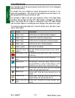
Page 111: ...1 92 Rev 2 Apr 2004 KMD 250 Pilot s Guide Section 1 Basic Operation Map Display Icons ...
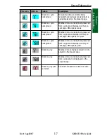
Page 112: ...1 93 Rev 2 Apr 2004 KMD 250 Pilot s Guide Section 1 Basic Operation Map Display Icons ...
Page 113: ...1 94 Rev 2 Apr 2004 KMD 250 Pilot s Guide Section 1 Basic Operation Map Display Icons ...
Page 273: ...I 14 Rev 4 Aug 2007 KMD 250 Pilot s Guide Index Index Intentionally left blank ...