1-41
Rev 2 Apr/2004
KMD 250 Pilot's Guide
Section 1
Basic Operation
USER WAYPOINTS
User waypoints can be entered as either user defined waypoints or as
airports. The KMD 250 allows for the programming of up to 1,000 user
waypoints. User waypoints are stored on the KMD 250 data card and
can be transferred to a new data card when installed.
These waypoints can be used for flight plans if the KMD 250 contains the
optional internal GPS, but only if the internal GPS is currently being used
for navigation. Flight plans running on an external GPS cannot utilize
waypoints stored in the KMD 250.
KMD 250 systems that do not have the internal GPS also allow user
waypoints to entered, but can only be used for marking points on the
map for such things as points of interest, landing locations not contained
in the database, etc.
ENTERING A USER WAYPOINT
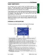
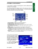
The following illustration describes the User Waypoint Edit display.
User Waypoints
1 Waypoint Identifier
- The system default will initially be USR000 and will increment with
each entered waypoint up to USR999. Any combination of alphanumeric characters
(up to six places) may be entered in place of the default.
2 1st Remarks Field
- The default entry is current date. This field may be cleared and any
combination of up to 24 alphanumeric and punctuation characters may entered.
3 2nd Remarks Field
- The default entry is current time. This field may be cleared and any
combination of up to 24 alphanumeric and punctuation characters may entered.
4 Waypoint Latitude/Longitude
- Initially, the aircraft position at the time this display was
selected is entered here. This field may be changed to place the waypoint at different
location.
5 Place
- A new waypoint is initially placed at the present position. An airport or navaid
identifier can also be entered to define the waypoint position as a bearing and distance from
the airport or navaid.
6 Bearing
- Can indicate bearing from the current aircraft position to the waypoint, or
a bearing may be entered to define a waypoint position relative to an airport or navaid.
7 Distance
- Can indicate distance from the current aircraft position to the waypoint,
or distance may be entered to define a waypoint position relative to an airport or navaid.
8 Waypoint Icon
- Waypoint symbol that will be displayed on the map.
9 Waypoint Type
- This field may be changed to indicate
Waypoint
or
Airport
depending
on the desired waypoint definition.
6
3
4
5
7
8
9
1
2
Summary of Contents for KMD 250
Page 1: ...B KMD 250 Multi Function Display GPS Pilot s Guide N ...
Page 9: ...R 6 Intentionally left blank ...
Page 19: ...Table of Contents x KMD 250 Pilot s Guide Rev 4 Aug 2007 Intentionally left blank ...
Page 111: ...1 92 Rev 2 Apr 2004 KMD 250 Pilot s Guide Section 1 Basic Operation Map Display Icons ...
Page 112: ...1 93 Rev 2 Apr 2004 KMD 250 Pilot s Guide Section 1 Basic Operation Map Display Icons ...
Page 113: ...1 94 Rev 2 Apr 2004 KMD 250 Pilot s Guide Section 1 Basic Operation Map Display Icons ...
Page 273: ...I 14 Rev 4 Aug 2007 KMD 250 Pilot s Guide Index Index Intentionally left blank ...

