


Revision 2 Nov/2002
KMD 550/850 FIS Addendum
11
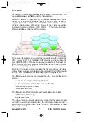
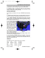
10. Echoes from migrating birds, bats, and insects will be displayed as
circular patterns of level 1 reflectivity centered near NEXRAD sites.
11. Significant variation in humidity with altitude can cause reflections
from the Earth's surface. These reflections are also displayed as large
circular or oval areas of uniform low intensity.
NEXRAD LIMITATIONS
The following are limitations on the use of NEXRAD Base Reflectivity
data:
1.
NEXRAD base reflectivity does not provide sufficient information to
determine cloud layers or precipitation characteristics (hail vs. rain, etc.).
2.
The displayed NEXRAD base reflectivity product does not provide
sufficient detail to infer future weather trends. Due to delays involved in
product creation and transmittal, the pilot should always review the age
bar to determine information currency.
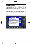
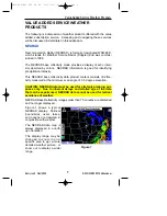
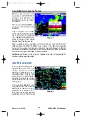
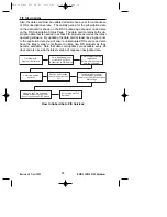
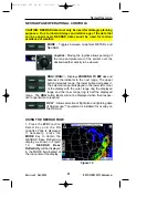
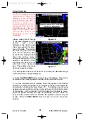
3.
Due to site location limi-
tations, terrestrial blockages
and outages, NEXRAD cov-
erage gaps exist. Coverage
gaps are displayed as a
cross hatched pattern as
shown in Figure 2. Lack of
reflectivity in a coverage gap
area should not be construed
as a lack of precipitation.
4.
NEXRAD base reflec-
tivity is sampled at the min-
imum antenna elevation
angle. An individual NEXRAD
site cannot depict high altitude storms at close ranges, and has no infor-
mation about storms directly over the site.
5.
The resolution of NEXRAD data is 4 kilometers. Thus, when
zoomed in on the display, each square block is 4 kilometers in diameter.
The intensity level reflected by the square will be the highest level sam-
pled within the 4 kilometer area.
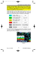
INTENSITY
Precipitation intensity is depicted using colors as follows:
Green
Light
Level 1
15-30 dBz
Yellow
Moderate
Level 2
30-40 dBz
Red
Heavy
Level 3-4
40-50 dBz
Magenta
Intense
Level 5-8
50+ dBz
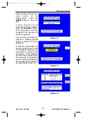
Figure 2
Value Added Service Weather Products
KMD 550/850 FIS PG R2 11/21/02 5:34 PM Page 11