20
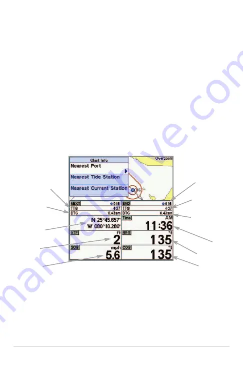
Chart Info:
Press the INFO key to get detailed information about the chart. If
the cursor is active, you will see information about the chart objects located
near the cursor. If the cursor is not active, the Chart Info submenu will appear.
Use the 4-WAY Cursor Control key to select the nearest port, the nearest tide
station, or the nearest current station and see information about any of these
objects.
NOTE:
The built-in UniMap™ does not contain any Port, Tide, or Current information.
This information is only available from optional-purchase MMC/SD cards.
Nearest Port:
The position and services information for the nearest port to your
present position will be displayed. Press the EXIT key to remove the information
box and the cursor bull’s eye will be centered over the port position. The cursor
information boxes at the bottom of the display will indicate the distance and
bearing to the port from your present position.
Chart Info Submenu
Last Waypoint
in Route
TTG: Time to Go
to Last Waypoint
DTG: Distance to
Go to Last
Waypoint
Time
BRG: Bearing
COG: Course
Over Ground
TTG: Time to Go
to Next Waypoint
DTG: Distance
to Go to Next
Waypoint
Latitude and
Longitude of Boat
XTE: Cross
Track Error
SOG: Speed
Over Ground
Views
Summary of Contents for 786ci
Page 65: ...56 Setup Tab Normal Mode Setup Tab Advanced Mode Main Menu ...
Page 136: ...127 Notes ...
Page 137: ...128 Notes ...


