CR3150
mobileIoT gateway
10
COB ID
Start byte
Length
(bytes)
Type
Object
Movement
0x01
4
4
R32
Gyroscope – X-axis
Movement
0x02
0
4
R32
Gyroscope – Y-axis
0
4
R32
Gyroscope – Z-axis
4.6 GNSS (global navigation satellite system)
The device has a GNSS receiver. The unit can forward the position data determined by the GNSS
receiver via the CAN bus or send it via the mobile network.
The device can evaluate signals from GPS, GLONASS and BeiDou satellites. Data from two
navigation systems can be evaluated simultaneously. This enhances the accuracy.
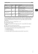
The GNSS data is accessed via the following objects:
Object
Index
Subindex
Type
Default
Description
Positioning – an-
tenna status
0x3333
0x13
U8
ro
—
0 = antenna damaged or missing
1 = antenna OK
Positioning – po-
sition data valid
0x3333
0x14
U8
ro
—
0 = position data invalid (no position detec-
tion)
1 = position data valid (position detection)
Positioning – ac-
tive satellites
0x5220
0x00
U8
ro
—
Number of currently active satellites
Positioning –
mode (GNSS)
0x5200
0x00
U8
rw
—
0 = GPS only
1 = GPS + GLONASS
2 = GPS + BEIDOU
3 = G BEIDOU
Positioning – lon-
gitude
0x5208
0x00
R32
ro
—
Longitude as a 32-bit floating point number
(decimal degrees)
Positioning – lati-
tude
0x5209
0x00
R32
ro
—
Latitude as a 32-bit floating point number
(decimal degrees)
Positioning – alti-
tude
0x520A
0x00
R32
ro
—
Height above mean sea level as a 32-bit
float (in mm)
Positioning –
speed over
ground
0x520B
0x00
R32
ro
—
Speed over ground as a 32-bit float (in m/s)
Positioning –
GPS odometer
0x520B
0x02
U32
ro
—
Total GNSS based distance as a 32-bit un-
signed integer (100 metres per bit)
Positioning – trig-
ger distance for
GPS odometer
0x520B
0x03
R32
ro
—
Distance in metres that the unit has to be
moved to start the odometer count
Positioning –
heading
0x520C
0x00
R32
ro
—
Course with respect to north as a 32-bit float
(decimal degrees)
Logging – cur-
rent GNSS posi-
tion
0x5200
0xF0
U8
rw
—
If this object is set to any value other than 0,
recording of the unit’s current GNSS position
starts.
If the unit has no GNSS reference point, it
waits for a reference point before logging the
position.
The flag remains on the written value until
the position has been recorded. It is then re-
set to 0.
The unit can send this data via the CAN interface. The configuration is made via the following objects:


