


Glossary
A
Altitude (GPS ALT): Altitude, as calculated by the
Apollo GX
, based upon a mathematical model of the
earth’s surface curvature. A substantial difference
between this altitude value and altitude referenced
to sea level may exist.
Altitude Assist: An aid that provides guidance in
descending from one altitude to another.
See the
Altitude Assist description on page 38 for details.
Almanac: Data transmitted by a GPS satellite
including orbit information on all satellites, clock
correction, and atmospheric delays.
ARC: A DME arc terminator with the preceding
flight plan leg is described as an arc to this waypoint.
An ARC waypoint may follow another ARC
waypoint.
ATC Ring: On the map display, an artificial ring five
nm in diameter is drawn around airports that have a
control tower.
Automatic Terminal Information Service (ATIS):
Recorded information about weather and other
conditions at an airport, periodically updated when
conditions change.
Autonav: The function that allows you to set the GX
to scroll automatically through selected navigation
displays .
Azimuth: an arc, as measured clockwise from true or
magnetic north.
B
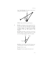
Bearing (BRG): The direction to any point, usually
measured in degrees relative to true or magnetic
north. The direction from your present position to
your destination waypoint.
265
Summary of Contents for Apollo GX 50
Page 1: ......
Page 17: ...I 270 K 270 L 270 M 270 N 271 O 272 P 272 R 272 S 273 T 273 U 274 V 274 W 274 xv ...
Page 18: ...xvi ...
Page 88: ...Notes 70 Moving Map Functions ...