
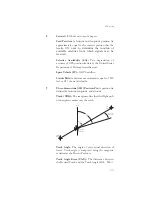


Magnetic Variation (Mag Var): The angle between
the magnetic and true north. At various points on the
earth it is different due to local magnetic disturbances.
It is shown on charts as isogonic lines marked with
degrees of variation, either east or west. These degrees
must be added to or subtracted from the true course to
get the magnetic course. (Easterly variations are
deducted, and westerly variations are added.) The
Apollo GX
automatically sets magnetic variation to
0 degrees at positions above 70 degrees north or
south latitude. See Declination.
MAHP: Missed Approach Hold Point.
MAP: Missed Approach Point.
Map Datum: A mathematical model of the earth used
for the purpose of creating navigation charts and
maps. The Apollo GX
uses the WGS-84 map datum.
MESA: Minimum Enroute Safe Altitude is the
highest MSA for every point between the aircraft
present position and the “TO” waypoint with a 5 nm
buffer around the course.
Meter (m): A metric distance measurement equal to
39.37 inches.
Minute: 1/60th of a degree.
MSA: Minimum Safe Altitude. The elevation of the
highest obstruction near the aircraft plus a 1,000 or
2,000
foot
buffer
added
for
safety.
In
non-mountainous terrain, a 1,000 foot buffer is added.
In mountainous terrain, a 2,000 foot buffer is added.
The result is rounded to the nearest 100 feet.
N
Nautical Mile (nm): A distance measurement equal
to 6,076 feet, or 1.15 statute mile. One nautical mile is
also equal to one minute of latitude.
271
Glossary
Summary of Contents for Apollo GX 50
Page 1: ......
Page 17: ...I 270 K 270 L 270 M 270 N 271 O 272 P 272 R 272 S 273 T 273 U 274 V 274 W 274 xv ...
Page 18: ...xvi ...
Page 88: ...Notes 70 Moving Map Functions ...