

13
User Manual
1
. Overview
1.1
CHART PLOTTER
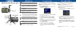
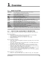
Cursor Key
: in the display screen moves the cursor quickly and accurately
in the menu page(s) scrolls the desired option
in Home mode, allows to exit from Home mode
POWER
: turns On/Off the chart plotter
adjusts the backlight and contrast of the display
MOB
: activates the MOB (Man OverBoard)
PAGE
: selects the screen configuration you wish
CLEAR
: if you are into a menu, exits from menu or leaves a menu without making changes
CM 11CV+/CM 11CVS+:
for 1 second activates the Video Input 2
ENTER
: if you are in chart page, places Marks, Waypoints and selects Range/Bearing
if you are into a menu, confirms selection
CM 11CV+/CM 11CVS+:
for 1 second activates the Video Input 1
HOME
: sets Home (Navigate) mode: the cursor is centered on ship's position
GOTO
: places the Destination (Target or Goto) and activates the navigation to it
MENU
: opens the menu on the top of the page
ZOOM IN
: increases the chart scale and zooms in on your display
ZOOM OUT
: decreases the scale and shows a wider view
Software Keys
: have different functions according to the modes of operation: their labels for the
current functions, located on the front panel, are shown on the screen right above the
keys.
1.2
C-MAP NT MAX CARTOGRAPHY INFORMATION
MAX is a major evolution of the NT/NT
+
product technology. Key points are:
New Data Features
♦
Tides and Currents (intuitive arrows show direction and strength)
♦
World Background Charts with terrestrial data
♦
Value Added Data (Pictures and Diagrams, Land Data)
♦
Enhanced Port Info
New Presentation Features
♦
Clear View (advanced legibility techniques providing more chart data
on the screen)
♦
Clear Info (sophisticated "Human Dictionary" to translate Nav-Aid ab-
breviations found on paper charts)
♦
Dynamic Nav-Aids (an innovative and dynamic presentation mode)
♦
Flexi-Zoom (increased Under and Over Zoom between chart levels, re-
sulting in optimal scale display for any situation)
♦
Dynamic Elevation Data (optimized palettes for chart plotters with 256
or more colors; includes new NOAA palette for US market)
♦
Perspective View ("Real World" perspective view of the chart, updated
real-time during navigation)
MAX and NT/NT
+
C-CARD coexistence
♦
When NT
+
data and MAX data cover different areas, the chart plotter
Summary of Contents for Chart Master 169CSI
Page 14: ...16 User Manual...
Page 34: ...36 User Manual...
Page 54: ...56 User Manual...
Page 72: ...74 User Manual...
Page 78: ...80 User Manual...
Page 81: ...83 User Manual INSTALLATION AND REMOVING EXTERNAL WIRING...
Page 84: ...86 User Manual...
Page 86: ...88 User Manual Dimensions...