


40
User Manual
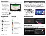
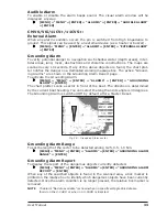
Caution
Red when “Guardian Technology” detects cautionary or restricted area.
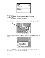
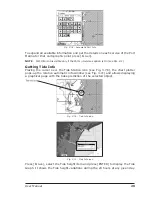
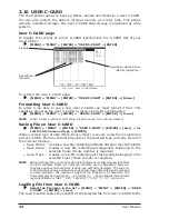
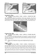
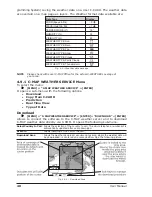
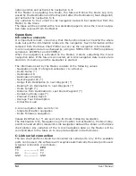
Currents Prediction
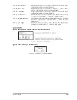
From the Chart page, [MENU] + "MENU" + [ENTER] + "CURRENTS PREDIC-
TION" + [ENTER]
A window is shown on the low-left side of the chart. It is possible to see the
variation of the Tidal arrows on the selected area at any given time. Press [S
ET
T
IME
] to set the date and time manually, press [I
NCR
]/[D
ECR
] to increase/decrease
time and [E
XIT
] to exit.
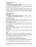
4.2
MAP
To set up the map layout:
[MENU] + "SETUP" + [ENTER] + "MAP" + [ENTER]
Allows the user to customize the following selections and is divided into: Marine
Settings, Depth Settings, Land Settings, Chart Settings and Underwater Objects
Settings.
Display Mode
[MENU] + "SETUP" + [ENTER] + "MAP" + [ENTER] + "DISPLAY MODE" +
[ENTER]
Selects from a predefined table what cartographic objects are displayed and which
display options are set. Preprogrammed settings are user selectable from Full,
Medium, Low, Radar, Tides, Custom. The table below shows the selections for
each mode:
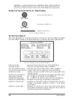
Setting
Full
Medium
Low
Radar
Tides
Custom
(Default values)
Place Names
On
On
On
On
On
On
Name Tags
On
Off
Off
Off
Off
Off
Nav Aids & Light Sectors
On
No Sector
No Sector
No Sector
Off
On
Attention Areas
On
On
Off
Off
Off
On
Tides & Currents
On
Off
Off
Off
On
On
Seabed Type
On
Off
Off
Off
Off
On
Ports & Services
On
On
Off
On
Off
On
Tracks & Routes
On
Off
Off
Off
Off
On
Depth Range Min (*)
0 Mt
0 Mt
0 Mt
0 Mt
0 Mt
0 Mt
Depth Range Max
9999 Mt
9999 Mt
9999 Mt
9999 Mt
9999 Mt
9999 Mt
Land Elevations
On
On
Off
Off
Off
On
Land Elevation Values
On
Off
Off
Off
Off
On
Roads
On
Off
Off
Off
Off
On
POI
On
Off
Off
Off
Off
On
Lat/Lon Grid
On
Off
Off
Off
Off
On
Chart Boundaries
On
Auto
Off
Off
Off
Auto
Value-Added Data
On
Off
Off
Off
Off
On
Chart Lock
On
On
On
On
On
On
Underwater Objects Limit
9999 Mt
10 Mt
10 Mt
10 Mt
10 Mt
10 Mt
Rocks
Icon+Depth
Icon
Icon
Icon
Icon
Icon
Obstructions
Icon+Depth
Icon
Icon
Icon
Icon
Icon
Diffusers
Icon+Depth
Icon
Icon
Icon
Icon
Icon
Wrecks
Icon+Depth
Icon
Icon
Icon
Icon
Icon
NOTE*
Only for color chart plotter.
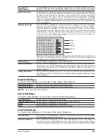
Marine Settings
To control the display on the map of the marine features.
Place Names
: Sets On/Off the displaying of the Names (local area names).
Name Tags
: Sets On/Off the displaying of a tag for particular chart objects that either
includes the Name of the chart object or the Depth of an Underwater chart
object. Available for Buoys, Towers, Beacons and Port Marinas.
Summary of Contents for Chart Master 169CSI
Page 14: ...16 User Manual...
Page 34: ...36 User Manual...
Page 54: ...56 User Manual...
Page 72: ...74 User Manual...
Page 78: ...80 User Manual...
Page 81: ...83 User Manual INSTALLATION AND REMOVING EXTERNAL WIRING...
Page 84: ...86 User Manual...
Page 86: ...88 User Manual Dimensions...