3-56
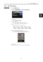
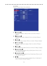
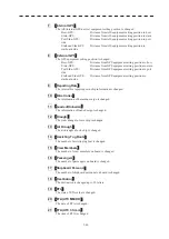
[Own Ship]
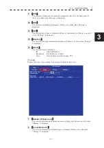
Display own ship information and alarm information.
1
࠙
Vessel Name
ࠚ
The received vessel name is displayed. If there is no valid value, "Missing" is
displayed.
2
࠙
MMSI Number
ࠚ
The received MMSI number is displayed. If there is no valid value, "Missing" is
displayed.
3
࠙
Call Sign
ࠚ
The received call sign is displayed. If there is no valid value, "Missing" is displayed.
4
࠙
Europe Number
ࠚ
The received Europe number is displayed. If there is no valid value, "Missing" is
displayed.
5
࠙
Ship Type
ࠚ
The received ship type is displayed. If there is no valid value, "Missing" is displayed.
6
࠙
Latitude Position
ࠚ
The received latitude is displayed with up to 4 decimal places. If there is no valid
value, "Missing" is displayed.
7
࠙
Longitude Position
ࠚ
The received longitude is displayed with up to 4 decimal places. If there is no valid
value, "Missing" is displayed.
8
࠙
COG
ࠚ
The received COG(course over ground) is displayed with up to 1 decimal place. If
there is no valid value, "Missing" is displayed.
Summary of Contents for JMR-611
Page 2: ......
Page 24: ......
Page 26: ......
Page 28: ......
Page 33: ...1 5 1 1 4 EXTERIOR DRAWINGS y Fig 1 1 Exterior Drawing of Scanner Unit Type NKE 387 Unit mm...
Page 34: ...1 6 Fig 1 2 Exterior Drawing of Processing Unit Type NDC 1774 Unit mm...
Page 35: ...1 7 1 1 4 EXTERIOR DRAWINGS y Fig 1 3 Exterior Drawing of Operating Unit Type NCE 5923 Unit mm...
Page 38: ......
Page 54: ......
Page 116: ......
Page 118: ......
Page 124: ......
Page 134: ......
Page 136: ......
Page 142: ......
Page 144: ......
Page 154: ......
Page 156: ......
Page 160: ......
Page 164: ......
Page 166: ......
Page 172: ......
Page 174: ......
Page 177: ...APPENDIX Fig 1 Block Diagram of JMR 611...
Page 181: ...APPENDIX Fig 5 Internal Connection Diagram of Control Unit NCM 994...
Page 182: ......
Page 184: ......
Page 186: ......
Page 187: ......

