p. 56
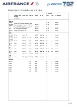
Aircraft track
Red
Last 16 minutes displayed.
Storm
Green
,
Yellow
,
Amber
,
Red
Magenta
Outlines only when selected but not active.
Full colour image when active. Colours
depict storm reflectivity (intensity).
Snapshot
Red
Red “S” in a circle and snapshot number.
Microburst
Magenta
Windshear
Magenta
Lat/Long grid
White
Spider Web
White
Aircraft location
White
TCAS traffic
If applicable. The relative altitude and a
vertical speed arrow (where applicable) are
displayed for each traffic symbol.
Red
square
Resolution advisory.
Amber
circle
Traffic advisory.
White lozenge
(solid)
Proximate traffic.
White lozenge
(wire frame)
Out-of-range aircraft.
By default the following are only displayed when the map scale is less than 20nm:
Colour
Comments
Outer markers
Yellow
Middle markers
Yellow
Inner markers
Yellow
ILS and LDA fans
Yellow
Orientated to the true heading of the
localiser beam.
Identification code
and frequency of ILS
and LDA
Yellow
Runways
Grey
Orientated to the true heading of the runway
axis.
Identification code of
runway in use
Grey
The map range can be set to one of a number of preset values to maintain the present map
centre and the current aircraft position on the map.
The aircraft track is shown as a line drawn from the centre towards the edge of the display.
As the edge of the display is reached, the scale of the map automatically changes to the next
available. When the aircraft approaches the edge of the largest map, the map mode changes
automatically to A/C North Up (with the aircraft at the centre).
5.3.1 A/C North Up
The map is centred on the aircraft with true north at the top of the screen. The navigational
facilities move in relation to the aircraft and the track is shown as a line leading backwards
from the aircraft. All other features are the same as Active Airport Mode.

