GeoCOM Reference Manual
Theodolite Measurement and Calculation – TMC
Leica TPS1200 – Version 1.50
140
17
T
HEODOLITE
M
EASUREMENT AND
C
ALCULATION
–
TMC
17.1
INTRODUCTION
This module is the central measurement, calculation and geodetic control module of the TPS1200 instrument family.
All sensors (angle, distance and compensator) deliver their respective data to this module. All sensor information is
used to continuously calculate corrected or uncorrected values for angles, distance and position co-ordinates.
The functions handled by the TMC module are:
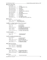
Measurement Functions
These functions deliver measurement results. Angle and inclination measurements are started by system
functions directly, other measurement operations needs activating the corresponding sensor (e.g. distance
measurement). This means a distance measurement needs to be previously activated in order to measure
coordinates. ATR corrected angle values are automatically delivered once the ATR status is on. For simple
measurements with a single procedure call, use the BAP MeasDist command.
Measurement Control Functions
These functions control measurement behaviour (activate/deactivate sensors) and basic data for the calculation of
measurement results.
Data Set-up Functions
These functions allow sending destination data, location data and section data to the Theodolite.
Information Functions
These functions return additional information about measurement results, sensors, Theodolite status, etc.
Configuration Functions
These functions control the Theodolite behaviour in general.
The measurement functions of this subsystem generally can generate three types of return codes:
System
Return Codes are of general use (
GRC_OK
means result is okay,...)
Informative
Return code indicates that the function was terminated successfully. But some restrictions apply (e.g. it
can be reported that the angle values are okay, the distance is invalid).
Error
Return Codes signal a non-successful termination of the function call.
17.2
USAGE
17.2.1
Inclination measurement/correction
The TMC module handles the inclination sensor data and correction. To get exact results (co-ordinates, angles,
distances) the inclination of the instrument must be taken into account. In general, there are two ways how this can be
done:
Measuring the inclination
Calculating the inclination
For a limited time of several seconds and a limited horizontal angle between 10 and 40 degrees (depending on
instrument type) an inclination model is generated to speed up measurement. The model for the inclination is based on
the last exact inclination measurement and is maintained within the TMC as a calculated inclination plane.
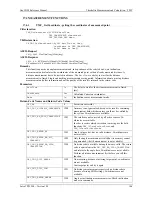
To control the kind of generating the results, all measurement functions have a parameter (of type
TMC_INCLINE_PRG
),
where the inclination mode can be selected. The different measurement modes are:
TMC_MEA_INC
:
Measures the inclination (in any case). Use this mode by unstable conditions like e.g. the instrument has been moved or
walking around the instrument may influence the inclination on an unstable underground (e.g. field grass). The
disadvantage of this mode is the longer measurement time compared to
TMC_PLANE_INC
.
TMC_PLANE_INC
:
Calculates the inclination (assumes that the instrument has not been moved). This mode gives an almost immediate
result (some milliseconds).
TMC_AUTO_INC
:
The system decides which method should be used (either
TMC_MEA_INC
or
TMC_PLANE_INC
). You get the best
performance regarding measure rate and accuracy with this mode; the instrument checks the conditions around the
station. We recommend taking this mode any time.


