96
User Manual
Fonts & Symbols
On MAX charts it is possible to set the size of all names and symbols drawn on the charts, selecting
between Normal size (the regular characters size) and Large size.
'MENU' +
"MAP SETTINGS" +'ENTER' + "Fonts & Symbols" + 'ENTER'
Formatting
The formatting of a User C-CARD must be done before using a new User C-CARD: this operation
prepares the User C-CARD to receive and store information. Before you start the formatting proce-
dure, insert a new User C-CARD into the slot. Be sure to label it; the label will remind you that you
have formatted the User C-CARD, and will help you identify its contents. An used User C-CARD can
also be formatted; if a used User C-CARD is formatted, however, all previously stored data on the User
C-CARD will be completely deleted (see Par. 4.6).
'MENU' +
"ADVANCED SETTINGS" + 'ENTER' + "USER C-CARD" + 'ENTER' + "FORMAT" +
'ENTER'
Goto
Sets a particular mark on the map, called Target or Destination (see Par. 3.4, 4.1.1.4 and 4.2.1.3).
'DEST'
GPS = Global Positioning System
It is a satellite based navigation system operated by the US Department of Defense. It gives the naviga-
tor a position 24 hours a day, 365 days a year under any weather conditions.
GPS Cable Wiring
Displays the Cable Wiring page for GPS.
'MENU' +
"BASIC SETTINGS" + 'ENTER' + "INPUT/OUTPUT" + 'ENTER' +"GPS CABLE WIR-
ING" + 'ENTER'
GPS Data Page
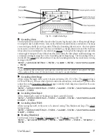
The GPS Data Page shows in graphic mode GPS data.
'<PAGE>'
Fig. 5b - GPS Data Page
On the right side of the screen (see Fig. 5b), there is a polar representation of the azimuth and elevation
of each satellites. The circle contains a number indicating the PRN of the satellite and it is filled when
it is used for the fix solution. On the left side there are histograms indicating the S/N ratio (SNR). The
bar is filled when the satellite is used for solution. As example, the satellite with PRN=10 is used for
solution with S/N=44, Azimuth=127degree and Elevation=70degree. When a valid fix is received,
the Lat/Lon, Date, Time, HDOP, VDOP, SOG, COG and Altitude are shown in the page.
Graphic Data Page
The Graphic Data Page shows in graphic mode navigation data.
Summary of Contents for MAGNUM PLUS
Page 8: ...10 User Manual ...
Page 12: ...14 User Manual ...
Page 22: ...24 User Manual ...
Page 46: ...48 User Manual ...

