163
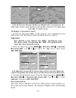
Left, entrance to Chesapeake Bay in a MapCreate 6 custom map, 10
mile zoom. Center, same position on Navionics chart at 11.15 mile zoom
and right, 5.56 mile zoom.
To display a Navionics chart:
1. Install the Navionics MMC in the memory card compartment and
turn on the unit. (For full card install instructions, see Sec. 2.)
WARNING
You should never format the MMC containing your
Navionics chart. Formatting the MMC will permanently
erase the chart from the card.
2. From the Map Page, press
MENU
|
↓
to
M
AP
D
ATA
|
ENT
|
↓
to
N
AVIONICS
M
AP
C
HOICE
|
ENT
. Use
↑
or
↓
to select the
Map Name
, then press
ENT
|
EXIT
|
EXIT
.
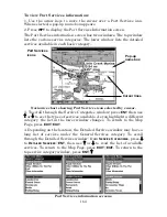
Left, Map Data menu with Navionics Map Choice selected. Right, the
South Chesapeake Navionics chart is chosen from the map choice list.
3. To turn off a Navionics chart, From the Map Page, press
MENU
|
↓
to
M
AP
D
ATA
|
ENT
|
↓
to
N
AVIONICS
M
AP
C
HOICE
|
ENT
. Use
↑
or
↓
to select
L
OWRANCE
, then press
ENT
|
EXIT
|
EXIT
.
Port Information
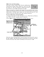
Navionics charts contain Port Services information, represented by an-
chor icons on the map display. An example is displayed in the following
figure.
Summary of Contents for LMS-332C
Page 20: ...12 Notes ...
Page 52: ...44 Notes ...
Page 61: ...53 Notes ...
Page 68: ...60 Notes ...
Page 106: ...98 Notes ...
Page 110: ...102 Notes ...
Page 190: ...182 Notes ...
Page 208: ...200 Notes ...
Page 212: ...204 Notes ...
Page 213: ...205 Notes ...

