Chapter 13 Device Logic (Pawn)
13.2.8.3 Functions
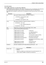
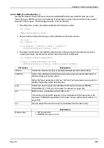
native rM2M_SetPos(Lat, Long, Elev, Qual, SatUsed);
Saves the GPS position information in the device. A historical record is not maintained. This means that
the current position information always overwrites the last known position. The information is
transmitted to the myDatanet server and can, for example, be read out via the API (see "API" on page
245).
Parameter
Explanation
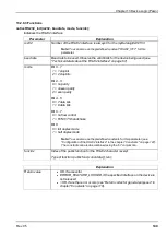
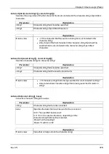
Lat
geographical latitude in degrees (resolution: 0.000001°)
-90 000 000 = South pole 90° south
0 = Equator
+90 000 000 = North pole 90° north
Long
geographical longitude in degrees (resolution: 0.000001°)
-180 000 000 = 180° west
0 = Zero meridian (Greenwich)
+180 000 000 = 180° east
Elev
Height above sea level in meters (Valid range: -999...+9999)
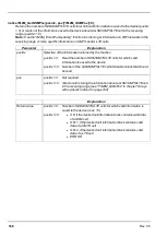
Qual
Quality indicator (GPS quality indicator)
RM2M_NMEA_FIX_NOK:
invalid/no fix
RM2M_NMEA_FIX_GPS:
non-differential GPS fix
RM2M_NMEA_FIX_DGPS:
differential GPS fix
RM2M_NMEA_FIX_PPS:
Precise positioning service (PPS)
RM2M_NMEA_FIX_RTK:
Real time kinematic (RTK)
RM2M_NMEA_FIX_FLOATRTK:
Float real time kinematic
RM2M_NMEA_FIX_EST:
Estimated fix (dead reckoning, coupled
navigation)
RM2M_NMEA_FIX_MAN:
Manual input mode
RM2M_NMEA_FIX_SIM:
Simulation mode
SatUsed
Number of satellites used for the positioning (valid range: 0 ... 99)
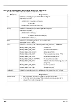
Explanation
Return value
l
OK, if successful
l
ERROR
Note:
The parameters are checked against the specified range limits. The
function returns "ERROR" if the limits are not adhered to.
Rev. 05
163
Summary of Contents for myDatalogEASY V3
Page 2: ......
Page 13: ...Chapter 2 Declaration of conformity Chapter 2 Declaration of conformity Rev 05 13 ...
Page 14: ......
Page 42: ......
Page 76: ......
Page 88: ......
Page 102: ......
Page 110: ......
Page 116: ......
Page 234: ......
Page 244: ......
Page 252: ......
Page 254: ......
Page 266: ......
Page 276: ......

