

16
GROUND STATIONS
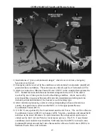
LUTs are the ground stations that track COSPAS-SARSAT satellites in their
paths across the sky and receive the distress signals relayed by them. A LUT consists of
a parabolic antenna, a processor, and communications equipment. The LUTs are fully
automated, completely unmanned at all times and operate on inexpensive micro
computers. Once a signal is received and processed at the LUT it is transmitted to the
mission control center (MCC) that operates that particular LUT. In the U.S., NOAA
operates fourteen LUTs in seven locations. This provides total system redundancy and
allows for a maximization of satellite tracking.
SATELLITES
The keystone to the COSPAS-SARSAT System are the polar orbiting satellites
from which the system takes its name. These satellites provide the ability to detect and
locate (via Doppler Shift calculations) 406 MHz alerts worldwide and 121.5 MHz alerts
for about sixty percent of the world.
SARSAT is an instrument package flown aboard the NOAA Series of
environmental satellites operated by NOAA's National Environmental Satellite, Data and
Information Service (NESDIS). These satellites orbit at an altitude of 528 miles and
complete an orbit every 100 minutes. Their orbits are inclined 99 degrees from the
equator. Each satellite carries a Search and Rescue Repeater (SARR) which receives
and retransmits 121.5 MHz and 243 MHz signals anytime the satellite is in view of a
ground station. Also carried is a Search and Rescue Processor (SARP) which receives
406 MHz transmissions, provides measurements of the frequency and time, then
retransmits this data in real-time and stores it aboard for later transmission. If the
satellite is in view of a ground station when a 406 MHz signal is received the data is
received in real-time. The satellite also stores each signal it receives and continuously
downloads this data. The ground stations (LUT’s) use the data to calculate the position
of the beacon via Doppler Shift. If the satellite was not in view of a ground station when
it received a beacon signal, the next ground station that sees that satellite will receive the
data. This provides global coverage for 406 MHz distress signals. The SARR is
provided by the Canadian Department of National Defence and the SARP is provided by
the French Center National D'Etudes Spatiales (CNES).
The COSPAS instrument is carried aboard the NADEZHDA navigation
satellite orbiting the Earth every 105 minutes at an altitude of 620 miles and an orbital
inclination of 83 degrees. The COSPAS instrument was built by the former Soviet
Union and continues to be operated by the Russian Federation. The major difference
between COSPAS and SARSAT is that the Russian satellites do not receive 243 MHz
distress signals and they do not have data storage and forward capabilities.
In addition to the polar orbiting satellites, there are several geostationary earth
orbiting (GEO) satellites. Geostationary satellites continuously view large areas of the
Earth, and thus can provide immediate alerting and identification of 406 MHz beacons.
The GEO satellites are not able to use Doppler location processing since they have no
relative motion between them and the emergency beacons.