background image


www.navig8r.com.au 


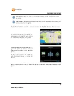
5: Battery Level Indicator

This  icon  shows  the  current  level  of  charge  remaining  in  t

connected to an external power source like the USB port of the computer or the car adaptor


Tap  on  the  Battery  Level  Indicator  icon  to 
show the battery level displayed in percentage when not connected to external power source. 
 
Tap on the Back or Map button to return to the Main Map screen.


6: Next Turn Indicator / 

Spoken Direction Button

During Navigation mode an icon is shown on the screen to indicate the type of action to be taken at 
the next intersection. There are 2 types of icons you can have displayed. 
Please refer to the “Look & Feel” 


Indicator 

The Indicator view displays an icon that is indicative of the next turn 
only. This icon may not truly represent the upcoming turn and is meant 
as a visual guide only.


ATA 

Advance Turn Assist, 
approaching int
intersections. 


Green with + 

Indicates that the GPS unit is connected to an external power source 
and is charging.


Red 

Indicates that the battery
power source as soon as possible


Amber 

Indicates that the battery is approximately half charged.


Green 

Indicates that the battery is fully or near fully charged.


MAIN MAP SCREEN

Battery Level Indicator 

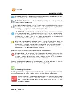
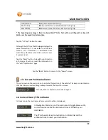
This  icon  shows  the  current  level  of  charge  remaining  in  the  battery  or  if  the  unit  is 

connected to an external power source like the USB port of the computer or the car adaptor

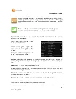
Tap  on  the  Battery  Level  Indicator  icon  to  show  the  battery  information  screen.  This  screen  will 
show the battery level displayed in percentage when not connected to external power source. 

Tap on the Back or Map button to return to the Main Map screen. 

Next Turn Indicator / Advance Turn Assist (ATA) & Repeat Last 

Spoken Direction Button 

During Navigation mode an icon is shown on the screen to indicate the type of action to be taken at 
the next intersection. There are 2 types of icons you can have displayed.  
Please refer to the “Look & Feel” for information about selecting these options. 

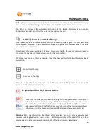
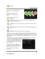
The Indicator view displays an icon that is indicative of the next turn 
only. This icon may not truly represent the upcoming turn and is meant 
as a visual guide only. 

Advance Turn Assist, if selected can display a representation of the 
approaching intersection. This is very useful if approaching complex 
intersections.  

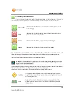
Indicates that the GPS unit is connected to an external power source 
and is charging.


Indicates that the battery level is low and should be connected to a 
power source as soon as possible


Indicates that the battery is approximately half charged.

Indicates that the battery is fully or near fully charged.


18

MAIN MAP SCREEN


he  battery  or  if  the  unit  is 

connected to an external power source like the USB port of the computer or the car adaptor

show  the  battery  information  screen.  This  screen  will 

show the battery level displayed in percentage when not connected to external power source.  

& Repeat Last 

During Navigation mode an icon is shown on the screen to indicate the type of action to be taken at 


The Indicator view displays an icon that is indicative of the next turn 
only. This icon may not truly represent the upcoming turn and is meant 

f selected can display a representation of the 

if approaching complex 

Indicates that the GPS unit is connected to an external power source 

level is low and should be connected to a 

Indicates that the battery is approximately half charged. 

Indicates that the battery is fully or near fully charged.
 

Summary of Contents for GPS

Page 1: ...he Following 11 Key Features 11 Getting started with your Navig8r GPS System 12 MAIN MAP SCREEN 13 Getting to Know the Main Map Screen 13 1 Next Turn by Name Turn By Turn Menu 15 2 Low GPS Satellite S...

Page 2: ...In and Out of Maps 23 18 Scrolling Maps 24 19 Waypoint Navigation 24 20 Lane Assist 25 Main Menu The Main Menu 26 Modern Menu 26 Classic Menu 26 1 Driver Profiles 27 2 The Navigation menu 29 Classic M...

Page 3: ...edAlert Settings 47 Sound 48 Help 49 About 50 Record 51 Free Driving 52 Business Driving 52 Supervised Driving 53 Generating Reports 53 Installation 54 Generating Reports 56 ACCESSING THE RECORDED FIL...

Page 4: ...u 4 TABLE OF CONTENTS G Music 67 H Video 68 System Settings 69 A Volume 70 B Langauge 70 C Backlight 70 D Battery 71 E Time Date 71 F System Information 72 Specifications 73 Disclaimer 73 Frequently A...

Page 5: ...ded in the software mapping data of this product When leaving your vehicle do not leave the Navig8r on the dashboard of the car It should be removed and placed in a secure place along with the windscr...

Page 6: ...unit 2 GPS device holder including stylus 3 Bracket Windscreen Mount 4 Car Charger 12v DC 5 USB Data Cable 6 2GB Micro SD card Pre fitted to GPS Getting to Know Your Navig8r GPS Item Description Item...

Page 7: ...operation Connect the Navig8r GPS unit to power source for a period of 24 hours in the first instance to charge and condition the battery It may take several charge discharge cycles for the device to...

Page 8: ...ng In a normal driving position adjust the GPS to a position that will be in view whilst driving and does not obstruct your view of the road Once the correct position has been found tighten the two kn...

Page 9: ...now be started by pressing the power button on top of the device for about 3 seconds When starting the GPS in the vehicle it may take a short period of time for the system to acquire a valid GPS signa...

Page 10: ...www navig8r com au 10 NAVIGATION NAVIGATION...

Page 11: ...road ahead and ensure the driver does not have to look away from the road to check the screen Please read the hardware section to ensure that all accessories can be identified and you can assemble the...

Page 12: ...ess the power button the Navig8r The Navigation software will run automatically elp screen is displayed the start up screen will be shown is first started you will be presented with the options shown...

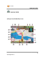
Page 13: ...www navig8r com au MAIN MAP SCREEN Getting to Know the Main Map Screen MAIN MAP SCREEN MAIN MAP SCREEN Getting to Know the Main Map Screen 13 MAIN MAP SCREEN...

Page 14: ...t Displayed when within 250 meter of known camera location camera 9 Compass Shows current heading in relation to North 10 Exit to Main Menu Button Exits Map screen to the main menu 11 Current Speed In...

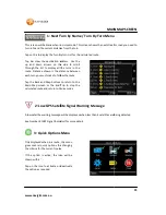
Page 15: ...activate or deactivate the option as required MAIN MAP SCREEN Next Turn by Name Turn By Turn Menu This screen will be blank when in cruise mode This screen shows the next street or road you need to tu...

Page 16: ...ed route if you miss a turn The Full Recalc option allows for the full recalculation to ensure that the best route from your current location is used Use this option to find a way around an accident o...

Page 17: ...s receiving a valid signal from The number the greater the accuracy of the Navig8r Up to 12 satellites can be detected at any one Shows the current speed in Kilometres per hour degrees for the current...

Page 18: ...to the Main Map screen Next Turn Indicator Advance Turn Assist ATA Repeat Last Spoken Direction Button During Navigation mode an icon is shown on the screen to indicate the type of action to be taken...

Page 19: ...Zoom level can be set by the driver to a level that they feel comfortable with and see clearly whist driving When it is not possible to either zoom in or out of the map these buttons will not be shown...

Page 20: ...he direction of travel This feature is Main Menu Button ns the Main GPS menu for Settings Route and General Options and Destination options It will be displayed in red if Navig8r is in record mode Ple...

Page 21: ...ng navigated These pages only function in navigation mode and the data will be reset each time a new destination is chosen The information can be manually reset during the route by tapping the Reset b...

Page 22: ...SpeedAlert Data Text will be red if speed has been 15 eed limit at any time Tap the All Trips button for more atistics page displays the same information it is calculated in a different manner This i...

Page 23: ...the responsibility of the driver to be aware of the posted speed limit at all times LaserCo accept no responsibility for the accuracy of this information contained in the SpeedAlert Data Special Speed...

Page 24: ...screen to adjust your trip as required MAIN Scrolling Maps To view outside of the area displayed on the screen touch the screen and push away from For example If you wish to see the area behind your...

Page 25: ...ing the trip Add a new waypoint to you journey Start the trip For more information on Waypoints please see page 20 Lane Assist In Navigation mode only this icon may be displayed to show what lane you...

Page 26: ...on is tapped the menu options will slide across the lower section of the l be displayed until the Back icon is tapped or the map area of the screen is Select an option as required or tap the Map butto...

Page 27: ...o continue Please note that the new profile will need to be selected after it is created DRIVER PROFILES Set the type of driver that is using the Navig8r and use it to record information from Learner...

Page 28: ...he correct profile is set with a For drivers on their Learners licences Sets the personal Speed limit of the Navig8r to 80 kilometres per hour for P1 license holders Sets the personal speed limit at 9...

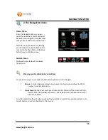
Page 29: ...this manual NAVIGATION avigation menu Navigation Menu you can search for an address Points of Interest and Favorites that you have added from previous trips Select the required option for selecting y...

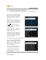
Page 30: ...for the street name the more refined the list is Use the list option to view more results or if the correct street is displayed tap on the OK button NAVIGATION MENU Entering your Destination by the 3...

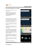
Page 31: ...rd option Once the correct number or cross street has been entered tap on the Ok button to continue The selected address will be displayed in a map screen with a shown to mark your destination If the...

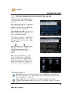
Page 32: ...creen NAVIGATION MENU Entering Your Destination Using Quick Step Method The alterantive to using the 3 Step Wizard ribed previously is the Quick Step Enter the street number the first 3 letters of the...

Page 33: ...button to return to the previous screen or the Map button show the map screen As with the 3 Step Mode your destination is displayed on the map for you to confirm or modify before beginning your journ...

Page 34: ...er depending on the assigned speed limits for the roads travelled The Walking option will calculate a route to your destination As the Crow flies The route will be shown in a straight line to you dest...

Page 35: ...peat as required When the list is populated you can alter the order or remove entries by selecting the entry to change and tap the Actions button Only the selected entry will be changed in this menu W...

Page 36: ...ing for is displayed Zooming in to the lowest level will allow you the greatest accuracy for a destination Tap the screen in the correct location to place the destination marker at the desired locatio...

Page 37: ...destinations the route may be too complex to calculate for one trip It may not be possible te from Melbourne to Broome because of the complexity and the location of this particular destination We rec...

Page 38: ...he options and when you have found the right catergory tap it to hightlight it and then press the OK button NAVIGATION MENU town and tap the OK Tap the List Keyboard button to swap between full list a...

Page 39: ...are looking for select it and then tap the OK button Tap the Confirm button to begin the trip to the location NAVIGATION MENU of all the Points of Interest around the area of your current Select the...

Page 40: ...points The order of the run can be changed and delivery points removed by selecting a delivery point and then tapping the Actions button NAVIGATION Tap the On Route button and then select the type of...

Page 41: ...cted delivery point from run Move Up Moves the selected point up the list Move Down Move the selected point down the list NAVIGATION MENU Each time a destination is selected and a route the destinatio...

Page 42: ...ress that you wish to keep for easy use at a later The list of Favourites will be displayed in To select a Favourite tap on the address When the destination is shown on the map tap the Confirm button...

Page 43: ...trip with only the suburb or town selected As the location will be positioned in the middle of the area selected the location maker may not be close enough to a road to calculate a valid route This o...

Page 44: ...The first group of buttons is for the display of the map The current options will be flagged by the Thick Style Daylight Maps 2D Default The look of these maps should be familiar to users of some map...

Page 45: ...h in relation to your direction of travel to Setting When Selected the screen will automatically change to night according to the time of day of your current location Digital Speedometer When selected...

Page 46: ...stination As the Crow flies The route will be shown in a straight line to you destination This feature is very useful if you are out of the road network or on the water as the Navig8r will always show...

Page 47: ...een as a standard speed limit symbol This feature includes visual and audiable warnings to let the driver of the vehicle know if they are going over the speed limit It also alerts the driver when the...

Page 48: ...he High Threshold lower than the mmended that a minimum of 3 Km h is kept between each value Please note that the Really high Over Speed warning cannot be turned off Please drive carefully Max Limit m...

Page 49: ...OPTIONS MENU Tap the Start Demo button to select and start a demonstration trip to show the action This is a useful tool to allow you to get use to the NAVIG8R in Navigation mode It can also be used t...

Page 50: ...release Date SpeedAlert shows the SpeedAlert Tap the Back button to return to the Options menu OPTIONS MEN The About screen shows Copyright information about the software and data button to technical...

Page 51: ...rips These records can then be printed out as a report or even shown in Google Earth er you are in navigation mode or simply free driving Please see the table below for type of information recorded fo...

Page 52: ...he map screen or the start button to begin recording Tap the type of recording that you would When recording is active all Types the menu button in the map screen is RED the recording at any time tap...

Page 53: ...ed The Odometer must be entered for each trip If the Supervising driver is an accredited teacher ensure that you have checked this option to ensure that your hours are logged correctly Tap the Back bu...

Page 54: ...Select the destination location of the software Click on Browse to select a different location to install the software It is recommended that the path be left as default Click Next to continue A Star...

Page 55: ...next to continue Confirm the instillation options before installing Click on the back button to go back to make changes or click on the install button to install the software When the installation is...

Page 56: ...e the software is started it checks for updates to ensure that you always have the latest version available requires an internet connection Please read and follow the onscreen instructions Click on th...

Page 57: ...as started Set the date range you wish to include on the finished report Click on the icon to display the calendar Change the date as required Once the range is correct click on the Next button Click...

Page 58: ...bilenavigator XXXX represents the last 5 digits of the Navig8r ID number This is to ensure that data from two different devices can be store separately on the same PC ACCESSING THE RECORDED FILES The...

Page 59: ...the top menu bar select File and then Open from the drop down menu Step 2 Use the pull down list to change the Files of type option to show GPS gpx loc mps Step 3 Pull down the Look in list to navigat...

Page 60: ...Step 5 Select the file you wish to display and click on the Open button Step 6 Ensure that all options on the GPS Data Import page are selected and then click on the OK button Your route will now be o...

Page 61: ...RTH Zooming in will release the points recorded by the Navig8r GPS Double click on any point to see the details For further information on importing gpx or GPS data into Google Earth please refer to t...

Page 62: ...software for the Navig8r Please refer to the http www Navig8r com au website for detailed information and instructions concerning the update options for the Laser Navig8r GPS system Updates can only...

Page 63: ...for Bowling Clubs in the OV2 format will be used Connect you Navig8r GPS to your computer as described in the section Connecting the GPS to the computer in the first part of the manual This can be co...

Page 64: ...www navig8r com au 64 HARDWARE Hardware...

Page 65: ...ry status E E Book function Displays E Books stored on device or storage card F Video Icon Enters the Video playback screen G Music Icon Enters the Music playback screen H Settings Icon Enter the syst...

Page 66: ...ent time and date is displayed on the top menu bar System Time is set by Satellite signals Users must set Time zone in the settings menu to ensure correct time and Daylight Savings Zones If travelling...

Page 67: ...older containing the E Book files to display Tap the screen to display the control buttons Title File name Return to folder view Current Total page Load Book Mark Previous Next Exit G Music Play Pause...

Page 68: ...www navig8r com au 68 MAIN SYSTEM MENU H Video Play Pause Stop Previous file Next file Random Play Repeat Play Tap the screen to toggle control buttons Return folder view Exit and return to Main Menu...

Page 69: ...in the main menu C Backlight Adjusts the backlight level for the LCD screen D Battery Status Displays the current battery status E Time Date Sets the Time Date and Time Zone F System Information Reset...

Page 70: ...the previous screen without accepting the changes Tap to accept the changes B Langauge Tap the language to be displayed in the main system menu Tap or to return to the previous screen without accepti...

Page 71: ...Tap or to return to the previous screen E Time Date Date Set the System Date Time Set the System Time Zone Set your current location time Zone Tap to return to the previous screen without accepting th...

Page 72: ...esponding or detecting satellites correctly Reset the Hardware defaults of the Navig8r This does not change any settings made in Navigation Software From time to time it may be necessary to recalibrat...

Page 73: ...SB connector Mini Port Hot Start 3 sec Open Sky 130dBm Warm Start 32 sec Open Sky 130dBm Cold Start 38sec Open Sky 130dBm Satellite Reacquisition Time Accuracy 100 Ms Position Accuracy 5m Outdoor 135d...

Page 74: ...om at least 6 of these satellites GPS satellites transmit signals constantly These signals are aimed at earth based receivers such as GPS navigation systems Each satellite transmits data about its loc...

Page 75: ...PS unit is accurate to within 15 meters The GPS system is only as accurate as the mapping software in the unit If the map data is incorrect the visual representation of you location may not be display...

Page 76: ...cted by computers as Mass Storage devices simular to USB drives Macs running OSX 10 2 or later should be able to access the GPS and SD Card Slot by connecting with the supplied USB cable without the n...

Page 77: ...n your head or take your eyes of the road while driving Q I find it hard to enter an address while driving what should I do A The driver of a vehicle should not attempt to enter destinations or change...

Page 78: ...GPS drops out or has trouble syncing A CBD areas can have a canyon affect on GPS systems Not only can tall buildings hide the signal from GPS satellites it can also reflect the signals of the satelli...

Reviews: