M-Nav 760 | User Manual
35
7.3 Navigation
Icons
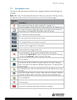
The route map has some special icons that help you navigate along the route and manage your
schedule.
Note:
After a time, the icons become transparent so that you can see more of the map, but they
are still active. When you touch the screen, the icons are shown in solid colour again.
Navigation
Icon
Description
Marks the location that you touched and displays the navigation menu.
Touch the map again to remove the icon OR choose an option from the navigation menu.
A mini-map that shows an enlarged view of your next manoeuvre and the distance to it.
Touch the icon in the upper left corner to hide or show the mini-map.
DTG - Distance To Go to the next via point.
ETA - Estimated Time of Arrival at the next via point.
TTG – approximate Time To Go to the next via point.
Local time (touch to toggle to the vehicle speed).
Vehicle speed (touch to toggle to local time).
Your present position. The arrow shows the direction that you are travelling.
The name of the
current road
is shown in the menu bar at the bottom of the screen.
The name of the
next road
is shown at the top of the screen.
Your start location.
After the route has been calculated, the green fl ags show the via points along your
route. The via points are numbered in sequence along the route. This example shows
the fi rst via point.
The calculated route is shown by a thick blue line and the blue direction arrows along
the roads.
A place that has been chosen as a via point. When the route is calculated, a thick blue
line appears along the road and links all the via points to show the complete route.
Your fi nal destination.
A favourite place.
Centre-on-me (shown only when the M-Nav 760 has a GPS signal).

