Chapter 12 - Alarms, TideTrack, Currents, and Echo Sounding
Page 12-14
961/962 Operations and Reference Manual, Rev. A
•
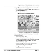
graphical tide height for any 24-hour period
•
the times of high and low tide (some days don’t have two
full tide cycles due to the time of the first high tide, as
illustrated above)
•
the scale range
On the tide graph, the light gray/dark gray vertical bars
represent nighttime hours; the light yellow/dark yellow bars
represent daytime hours. The red vertical line represents the
present time. Initially, the tides for today’s date and the
present time are displayed. To view the tides for past or future
dates, press the
CURSOR PAD
to highlight the day and date,
then press the
LEFT
or
RIGHT ARROW
keys to view past or
future dates, respectively. To view the tides for past or future
hours, press the
CURSOR PAD
to highlight the hour (e.g.,
03
),
then press the
LEFT
or
RIGHT ARROW
keys to view past or
future hours, respectively. To view the tides for past or future
minutes, press the
CURSOR PAD
to highlight the minutes
(e.g.,
46
), then press the
LEFT
or
RIGHT ARROW
keys to view
past or future minutes (in 5-minute increments only),
respectively.
For a selected a tide station, the
TIDE STATION
bar at the
bottom displays the distance and bearing to the selected tide
station, as well as its lat/lon coordinates and TDs.
For a selected a tide station, the scale-range reading can be
used to determine a precise mean low water depth reading,
printed on the chart, for that particular day. In most cases, you
add a positive number to the water depth printed on the chart.
On some days, however, the tide graph may have a dashed
black line at the bottom; this line is called the zero mark. The
presence of a zero mark means that the mean low depth of
water on the chart isn’t the lowest tide height for that
particular day. If you’re at this type of location, you should add
the negative number shown on the tide-graph scale range (for
example, -0.19 feet) to the water-depth number shown on the
chart (for example, 20 feet) to get a corrected water-depth
figure (for example, 19.81 feet).
To select tide stations other than the one nearest your vessel,
see below.
Summary of Contents for 961
Page 6: ...Page viii 961 962 Operations and Reference Manual Rev A ...
Page 8: ...Page x 961 962 Operations and Reference Manual Rev A ...
Page 14: ...Page xvi 961 962 Operations and Reference Manual Rev A ...
Page 92: ...Chapter 3 Using the Controls Page 3 34 961 962 Operations and Reference Manual Rev A ...
Page 160: ...Chapter 6 Creating Waypoints Page 6 18 961 962 Operations and Reference Manual Rev A ...
Page 176: ...Chapter 7 Creating Avoidance Points Page 7 16 961 962 Operations and Reference Manual Rev A ...
Page 202: ...Chapter 8 Creating Routes Page 8 26 961 962 Operations and Reference Manual Rev A ...
Page 380: ...Glossary Page G 8 961 962 Operations and Reference Manual Rev A ...


