I
GPS/GLONASS Glossary of Terms
GPS/GLONASS Receiver User Manual Rev 1
123
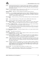
WGS84 — World Geodetic System 1984 is an ellipsoid designed to fit the shape of the entire Earth as well as
possible with a single ellipsoid. It is often used as a reference on a worldwide basis, while other
ellipsoids are used locally to provide a better fit to the Earth in a local region. GPS uses the center
of the WGS84 ellipsoid as the center of the GPS ECEF reference frame.
Waypoint — a reference point on a track.
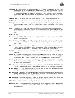
Wide Lane — a particular integer ambiguity value on one carrier phase range measurement or double
difference carrier phase observation when the difference of the L1 and L2 measurements is used. It
is a carrier phase observable formed by subtracting L2 from L1 carrier phase data: F' = F
1
- F
2
. The
corresponding wavelength is 86.2 cm
World Geodetic System — A consistent set of parameters describing the size and shape of the Earth, the
positions of a network of points with respect to the center of mass of the Earth, transformations from
major geodetic datums, and the potential of the Earth (usually in terms of harmonic coefficients).


