5.5.1.2 Line model
The line model is an effective tool when tracking long continuous targets such as pipelines, road
lines or trenches. When line model is used the system can display height difference, station
number and side measurement against the line model.
With these features the model can be applied to describe variable targets, due height remains the
same in the target, even when the position is changed.
Lines can be imported in DXF, LandXML, PXY, GT, and KOF formats
As an example, some practical methods for illustrating pipe grooves are:
•
Preparing geometry lines for pipes
•
Using different colours and descriptive naming to separate lines
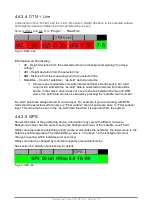
Both functions above the measurement tab's are the same:
dZ
Height difference between the bucket's measuring point and the selected line
dS
Sideways distance from the measuring point on the selected line
P
Station number, which in this case is calculated from beginning point of the line. Distance
can be defined to begin, for example, at 500 metres. When undefined it displays the
distance in metres from beginning of the line. (Fig 69)
Fig. 69 Station number
A is the starting point of the line and the B is the point on the line that is nearest to the bucket
measuring point. The station number is the distance between A and B along the line
User Manual. Xsite PRO SPI 14.2 Page 60 / 77
Summary of Contents for XSITE PRO SPI 14.2
Page 1: ...XSITE PRO SPI 14 2 USER MANUAL Version 1 14 2 46 October 2018...
Page 33: ...Fig 36 Tilt bucket calibration User Manual Xsite PRO SPI 14 2 Page 30 77...
Page 76: ...User Manual Xsite PRO SPI 14 2 Page 73 77...
Page 77: ...User Manual Xsite PRO SPI 14 2 Page 74 77...


