98
Pt.n:
Code:
Save
Enter
N:
E:
126595.622
326532.868
324.325
Z:
100.0
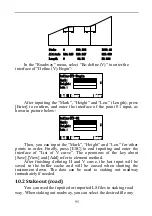
The ―Pt.n‖ indicates the mileage of the mark selected (which
system accepts the maximum of is 8 characters).then you can press
[Save] to save the information of staking out to the current coordinate
file. Press [Enter] to enter the interface of ―Roadway-Calc‖, which
displays the azimuth angle and horizontal distance:
Roadway-Calc
Coord.
Dist
HR:
HD:
68°48′31″
354.456
You can select F1[Dist] to stake out by polar coordinate or
F3[Coord.] to stake out by coordinate, which refer to ―9.2.2 Polar
Coordinates‖ and ―9.2.1 Stake out.‖ The key [ESC] in every interface
above can return to the interface of ―Roadway-Center/right/left‖ to
help you select mark to be staked out.


