
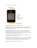


10
3.2.3 Calibration
Compass:
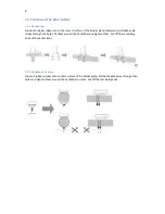
The electromagnetic compass can be recalibrated if it does not work properly. In the case a
recalibration becomes necessary. Please pay attention that you are out of reach of electromagnetic
sources during calibration process.
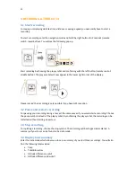
For calibration place your device flat on a table. After selecting the calibration function turn your
device horizontally in a circle.
Offset:
The GPS altitude may vary regionally from the actual altitude. With this function you can
adjust the offset. Just configure how many meters the actual altitude differs from the displayed
altitude. The offset to be entered is the sum you get when subtracting the displayed from the actual
altitude.
Example: Displayed altitude: 130m, actual altitude: 90m. 90m minus 130m = -40m. -40m is the offset
that has to be entered into your NAVI2move.
3.2.4 Units
Change between km (metric) and miles (English).
3.2.5 Tour
Turing radius:
The turning radius defines at what distance to a waypoint the device skips to the next
waypoint. The turning radius can be set up individually by the user.
Interval:
The recording interval defines the distance between two saved waypoints during recording.
Hiking mode
Presetting of turning radius (20m) and recording interval (10m) for all walkers, hikers and runners
Bike mode
Presetting of turning radius (40m) and recording interval (20m) for bikers.
User mode
Individual settings of turning radius and recording interval.
3.2.6 Totals
Set up for total data like total kilometres, time or altitude difference uphill and downhill.
ODO - total kilometres
Time - total time
3.2.7 Language
Set up the device language of your menu NAVI2move