background image

BT-Q1200 Super 99

®

 GPS Travel Recorder


4


3.1  Basic Mode provides simple setting for you. Select the transportation gear 

(Vehicle / Bicycle / Jog) you will use, and then click <Set> to set specific value 
to BT-Q1200. 

3.2  Advanced Mode let you setup two parameters of recording. Select the 

transportation gear (Vehicle / Bicycle / Jog) you will use and you can modify 
the default value per your requirement, and then click < Set > to set the 
updating and specific value to BT-Q1200.   

3.3  Professional Mode can be defined detail settings for all parameters manually. 

After complete all settings, click < Set > to set the values to BT-Q1200.   

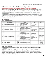
4. < CONFIGURATION > \ <Other Setting>, Setup the recording method for the flash 
memory of BT-Q1200 under <Other Setting>. 
5. <SATELLITE INFORMATION>, Display the current satellite viewer of your 
BT-Q1200 at < SATELLITE INFORMATION > tab. 
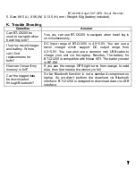
6. <DATA LOG LIST>, Access the log data which download from BT-Q1200. 


NOTE 1: Before accessing your log data of BT-Q1200, please establish the 
communication between BT-Q1200 and PC via mini USB cable. 
NOTE 2: Please install Google Earth before trying to download and draw map on 
Google Earth. 


6.1  Click <Download> button to download the log data from BT-Q1200. System 

will pop up a dialog box for asking to save the log file. After selecting a location 
to save, a message box pops up to show the progress status. It will take a few 
minutes depending on the data volume. After completing the log data 
downloading, those data will be shown on data grid. 

6.2  Click <Draw Map> button to display your log data on Google Earth. System 

will pop up a dialog box for setting the data period and drawing type. After 
click <OK> button, system will export the log data into Google Earth to 
display your travel path. You can check the detail information for each log 
point. 

7. <Photo Manager>, Allow you to manage the log files downloaded from BT-Q1200, 

combine GPS data with photos by Geotagging, and create KMZ file supported by 
Google Earth. 

    7.1 Click <GPS Log Manager> \ <View Log> to show the log data on data grid. On 

the “GPS Log Files” column is the log files from default location on the hard-disc 
(C:\Program Files\Qstarz\Travel Recorder PC Utility V3). You can add, delete, 
and delete all by clicking right button of mouse to show the function menu and 
executing each function and adjust the shown time by selecting time zone 
according to the local time. 

Summary of Contents for BT-Q1200 Super 99

Page 1: ...el Charger 5 Driver CD 6 Warranty Card User s manual Travel Charger plug type might be adjusted according to corresponding countries 1 2 3 4 5 6 B Appearance 1 Power jack mini USB type 2 Power Button ON OFF Enable LOG mode Disable LOG mode 3 Battery status LED Red Green 4 Bluetooth status LED Blue 5 GPS status LED Orange 6 Log status LED Blue 7 Internal antenna 8 Solar panel Auxiliary power source...

Page 2: ... in the unit and put battery cover on to the cabinet then push down and force it forward to fit firmly D 2 Take Battery out Press the PUSH button on the bottom side of the unit and pull out the battery cover Then take out the battery from the unit E Charging your battery For the first time using the BT Q1200 please charge battery until it is fully charged Take the power cable and connect it to the...

Page 3: ...ort no your PC is assigned for BT Q1200 NOTE Before checking the COM port please make sure the USB driver has been installed properly 2 1 Go to Start Settings Panel Control Performance and Maintenance System 2 2 Select Hardware tab and then click Device Manager 2 3 Expand the Ports COM LPT and check CP210x USB to UART Bridge Controller to see which COM port is for BT Q1200 G 3 Start the software u...

Page 4: ...ng to download and draw map on Google Earth 6 1 Click Download button to download the log data from BT Q1200 System will pop up a dialog box for asking to save the log file After selecting a location to save a message box pops up to show the progress status It will take a few minutes depending on the data volume After completing the log data downloading those data will be shown on data grid 6 2 Cl...

Page 5: ...shortcut in Bluetooth Manager window After the pairing complete the system will then find a quick connect device iBT GPS in Bluetooth Manager In further use you just need to click it to connect to this Bluetooth GPS Receiver H 3 Check the Serial Port in Bluetooth Setting After complete pairing with BT Q1200 please click Serial Port to confirm the assigned COM port If you use PDA PC to pair the GPS...

Page 6: ...rs LED Status Flash ON OFF 1 Power Red Green Low Power Red Fully charged Green Recharging Green 2 Bluetooth Blue Flash per 2 sec Bluetooth connected Flash per 5 sec Power saving mode Not connected Pairing GPS not powered 3 GPS Orange Blue Flash per 1 sec Orange GPS position is fixed Navigation Flash 3 times Blue POI Point of Interest is recorded Detecting Satellite GPS position not fix GPS not pow...

Page 7: ...e a travel charger which support DC output range from 4 5 5 5V You can also use a common mini USB cable to charge your unit via the laptop Besides The battery for BT Q1200 is compatible with Nokia N73 The battery model is BP 6M How can I know if my memory is full If you see the orange GPS light turns from orange to solid blue then that means the memory is full Can the logged data be downloaded thr...

Reviews: