background image

Quark-elec Manual

https://www.quark-elec.com

8 of 14

2018

V2.0

6.2. Connecting via USB port

A042T is supplied with a USB connector. This connector provides AIS, GPS data output as standard

This USB connector can be linked directly to a USB port on the PC. It can also be connected to other

mobile devices via an USB OTG (On the Go) connection using the supplied cable.

Windows:

To enable the USB data connection of A042T to other devices, related hardware drivers

may be needed dependent on your system requirements.

Windows 7,8,10

the driver can be found on the CD in the packing box or be downloaded from

https://www.quark-elec.com

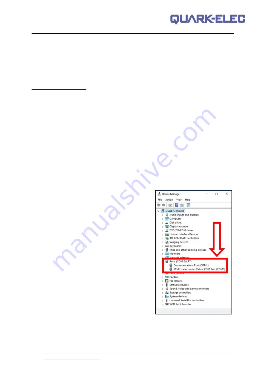
The A042T registers itself to the computer as a virtual serial com port.

The drivers usually install automatically to your device if it is running an original Windows 10 version.

A new COM port will automatically show up in the device manager after plug in.

Mac:

For Mac OS X, the A042T will be recognized and shown as a USB modem. The ID can be

checked with the following steps:

1. Plug the A042T into a USB port and launch Terminal.app.

2. Type: less /dev/*sub*

3. The Mac system will return a list of USB devices. A042T will display as - “/dev/tty.usbmodemXYZ”

where XYZ is a number. Nothing further needs to be done if it is listed.

Linux:

No driver is required for Linux. When plugged into the computer, A042T will show up as a USB

CDC device on /dev/ttyACM0.

6.3. Checking the USB connection (Windows)

After the driver is installed, run the Device Manager and check the

COM number

(this is the number

associated with the USB port you are using. The port number is the number that Windows assigns as

an input device. These can be generated randomly by your

computer). Your chart software may require your COM

number in order to access the data.

The port number for the A042T can be found in Windows

‘Control Panel->System->Device Manager’ under ‘Ports

(COM & LPT)’. Find the A042T in the list for the USB

variant. To change this number, double click the A042T and

select the ‘Port Settings’ tab. Click the ‘Advanced’ button

and change the port number to the one required.

Checking the USB data flow:

If desired, the USB data can

always be checked with a terminal monitor application, like

Putty or HyperTerminal. To do this, enter the following into

the COM port settings:

Bits per second: 38400bps

,

Data

bits: 8

,

Parity: None

, and

Stop bits: 1

as shown below

using HyperTerminal on Windows as an example

Summary of Contents for QK-A042T

Page 1: ... VHF range The ability to plot the progress changes in heading and speed of other AIS vessels on a PC or Chart Plotter Transmitter switch off facility to conserve power or for privacy Compatible with Windows Mac and Linux optional Configuration must be completed using Windows software This device connects to NMEA 0183 and is compatible with RS422 output devices NMEA 0183 RS232 devices can connect ...

Page 2: ... MMSI 4 5 Mounting 5 6 Connecting 6 6 1 NMEA POWER connection 7 6 2 Connecting via USB port 8 6 3 Checking the USB connection Windows 8 7 Configuration 9 7 1 GPS antenna location 10 8 Status LED S 10 9 Chart software 11 9 1 OpenCPN example USB setup 11 9 2 Maps 11 10 Specification 12 11 Troubleshooting 13 12 Limited Warranty and Notices 13 13 Glossary 14 ...

Page 3: ... There are two classes of AIS unit fitted to vessels Class A and Class B In addition AIS base stations may be employed by the Coastguard port authorities and other authorized bodies AIS units acting as aids to navigation AtoNs can also be fitted to fixed and floating navigation markers such as channel markers and buoys Class A units are a mandatory fit under the safety of life at sea SOLAS convent...

Page 4: ...Knots 3 min Ship with Speed Over the Ground 2 Knots 30 sec Ships Static Information 6 min 4 Maritime Mobile Service Identity MMSI IMPORTANT In most countries the operation of an AIS unit is included under the vessel s marine VHF license provisions The vessel on to which the AIS unit is to installed must therefore possess a current VHF radiotelephone license which lists the AIS system and the vesse...

Page 5: ...be used to attach it to a suitable surface It is not waterproof so should be mounted in a dry place on a flat surface Ideally the LED s need to be visible to the operator at all times The ambient temperature around A042T receiver should be maintained between 25 C and 55 C A042T should not be located in a flammable or hazardous atmosphere such as in an engine room or near to fuel tanks ...

Page 6: ... external GPS antenna 9 pins POWER NMEA connector 9 pin coaxial female connector mounted on the enclosure It provides power input and NMEA input output NMEA 0183 data can be connected with chart plotters or other NMEA0183 compatible equipment VHF connector an N type female bulkhead connector for external VHF antenna Connect external VHF antenna USB Type B USB connector for software configuration a...

Page 7: ...k Chart plotter To display received AIS position reports from other vessels on your chart plotter you will need to connect your A042T to your chart plotter or NMEA bus Please refer to the user manual supplied with your chart plotter for details of how to connect and configure your chart plotter for use with AIS devices For general guidance your chart plotter should be configured to accept NMEA dat...

Page 8: ... system will return a list of USB devices A042T will display as dev tty usbmodemXYZ where XYZ is a number Nothing further needs to be done if it is listed Linux No driver is required for Linux When plugged into the computer A042T will show up as a USB CDC device on dev ttyACM0 6 3 Checking the USB connection Windows After the driver is installed run the Device Manager and check the COM number this...

Page 9: ...nd the bottom of the hull keel with the thickness of the hull included Draft determines the minimum depth of water a ship or boat can safely navigate Name Enter the name of your vessel ETA Estimated Time of Arrival to destination entered below Destination This is the destination your vessel is heading to This should be entered before every journey ideally Ship type This field should contain a numb...

Page 10: ...m port to GPS antenna in metres D Distance from Starboard to GPS antenna in metres 8 Status LED S The A042T has 5 LED lights to show the internal workings and for troubleshooting any problems with the unit GPS GPS LED will stay lit once a GPS connection is established This will flash if there is a drop in the connection TX The TX LED will flash for every class B signal sent from A042T RXA RXB The ...

Page 11: ...openCPN software You now need to add data to openCPN via your Quark elec instruments Click on the Options tab at the top The settings tab looks like a spanner as seen below in the highlighted image 2 In the options at the top of the menu will be a tab button that says Connections Click on this 3 Click on Add Connection button highlighted in the picture below 4 Select Serial 5 Select from the drop ...

Page 12: ... RM 1371 IEC 60945 IEC 61162 NMEA 0183 38400 bps Sensitivity 110 dBm Power 2W Channel A CH87B 161 975MHz Channel B CH88B 162 025MHz Input Level 9 6V 36 0V Transmit Mode CSTDMA Bandwidth 25 KHz Bit ratio 9600 bps Consumption 4 W Working Temperature 15 55 Store Temperature 25 70 Humidity 0 95 RH at 40 Water resistance IPx2 ...

Page 13: ...rts and labour The customer is however responsible for any transportation costs incurred in returning the unit to Quark Elec This warranty does not cover failures due to abuse misuse accident or unauthorized alteration or repairs A returns number must be given before any unit is sent back for repair The above does not affect the statutory rights of the consumer Disclaimer This product is designed ...

Page 14: ...ansponder Similar to a cell phone number your MMSI number is your unique calling number for that AIS transponder IMO International Maritime Organization is a unique identifier for ships and for registered ship management companies For ships it consists of the three letters IMO followed by the seven digit number assigned to all ships Draught Draft is the vertical distance between the waterline and ...

Reviews: