1. OPERATION
1-57
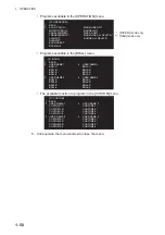
Depth menu
Right-click the depth icon ([DPT]) to show [DEPTH MENU].
Click [SELECT DUAL SENSOR]. Then, click the depth sensor to use to show depth
data, [FRONT] or [AFT].
Own ship position menu
Right-click the own ship position icon to show [OWN SHIP POSITION MENU].
1.35.2
How to show wind data or date alternately
Click the icon shown below to show wind data or date alternately.
• [SELECT DUAL SENSOR]: Select the sensor data, [FRONT] or [AFT].
• [SHIP SPEED]: Select the speed indication format, [SOG] (speed over ground) or
[STW] (speed towards water).
• [GROUND SPEED SOURCE]: Select the input source for SOG.
• [WATER SPEED SOURCE]: Select the input source for STW.
• [MANUAL SPEED]: Input the speed manually.
• [SET DRIFT]: Turn on or off drift.
• [SET CURRENT CRS]: Set the direction of the tide.
• [SET CURRENT SPD]: Set the speed of the tide.
• [NAV AID]: Click the source of ship position data, [GPS] or [DEAD RECKON] (dead
reckoning).
• [MANUAL L/L]: For [DEAD RECKON], enter the latitude and longitude, using the soft-
ware keyboard.
Right-
click
1 BACK
2
SELECT DUAL SENSOR
FRONT/AFT
CAPT
±300 °/min
±180 °
CURSOR TTG
18m20s
01-sep-2012
►
44. 6km/h
3. 2m
SPD BT GPS-F
►
SPD BT GPS-F
►
Depth
icon
DPT AFT
►
DPT AFT
►
[DEPTH
MENU]
6.34NM / 300.3°R
UTC
12:34
Right-
click
±300º/min
±180º
CURSOR TTG
18m20s
2. 4m/s
WIND
CAPT
CAPT OS POSN N
OS POSN N
0° 00. 219°
0° 00. 219°
E
E
0° 00. 397°
►
0° 00. 397°
►
Own ship position icon
[OWN SHIP POSITION MENU]
1 BACK
2 NAV
AID
GPS /DEAD RECKON
3 MANUAL
L/L
00˚00.000 N
000˚00.000
E
6.34NM / 300.3°R
Wind speed
Date
(at the top right corner on the screen)
Click
CAPT
±300°/min
±180°
SPD BT GPS-F
►
DPT AFT
►
CURSOR TTG
18m20s
44. 6km/h
3. 2m
CAPT
±300°/min
±180°
OS POSN N
CURSOR TTG
18m20s
2. 4m/s
0° 00. 219°
E
0° 00. 397°
►
WIND
WIND
6.34NM / 300.3°R
01-sep-2012
►
01-sep-2012
►
6.34NM / 300.3°R
UTC
12:34


