


Weather Station - Model “PRO”
Model “PRO” - Weather Station
Page
5
Nov., 2001
GT27145B Cozz
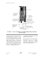
A rain gage should be located over level
ground that is covered with short grass
or gravel. In open areas, the distance to
obstructions should be two to four times
the height of the obstruction.
The height of the opening should be as
low as possible, but should be high
enough to avoid splashing from the
ground.
The gage must be mounted above the
average level of snow accumulation in
areas that experience significant
snowfall.
Standard measurement heights:
1.0
meter +/- 1.0 cm (AASC)
30.0
centimeter minimum
(WMO, EPA)
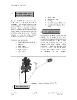
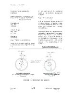
(d)
DETERMINING TRUE
NORTH FOR WIND
VANE OREINTATION
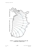
Magnetic declination, or other methods
to find True North, should be
determined prior to installing the
weather station. True North is usually
found by reading a magnetic compass
and applying the correction for magnetic
declination. (Other methods employ
observations using the North Star or the
sun, and are discussed in the Quality
Assurance Handbook for Air Pollution
Measurement Systems, Volume IV -
Meteorological Measurements.) The
magnetic declination is the number of
degrees between True North and
Magnetic North. Magnetic declination
for a specific site can be obtained from a
USFA map, local airport, or through a
computer service offered by the USFS
called GEOMAG (see page 7). A
general map showing magnetic
declination for the contiguous United
States is shown below in FIGURE 2.
Declination angles east of True North are
considered negative and are subtracted
from 0 degrees to get True North.
Declination angles west of True North
are considered positive and are added to
0 degrees to get True North. For
example, the declination for Logan,
Utah is 16 degrees East. True North is
360 degrees minus 16 degrees, or 344
degrees as read on a compass.
REFER TO NEXT PAGE FOR FIGURE 2