background image

17

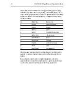
Appendix

Appendix A

Additional Local Geodetic Systems

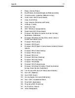
11

Adindan  (Mean for Ethiopia and Sudan)

12

ARC 1950  (Mean for Botswana, Lesotho, Malawi, Swaziland,
Zaire, Zambia, Zimbabwe)

13

Australian Geodetic 1984  (Australia)

14

Bermuda 1957  (Bermuda Islands)

15

Bogota Observatory  (Columbia)

16

Campo Inchauspe  (Argentina)

17

Chatham 1971  (Chatham Island)

18

Chua Astro  (Paraquay)

19

Corrego Alegre  (Brazil)

20

Djakarta (Vatavia)  (Sumatra)

21

European 1979  (Europe)

22

Geodetic Datum 1949  (New Zealand)

23

Guam 1963  (Guam)

24

Hayford 1910  (Finland)

25

Hjorsey 1955  (Iceland)

26

Indian  (India and Nepal)

27

Ireland 1965  (Ireland)

28

Kertau 1948  (West Malaysia and Singapore)

29

L.C.5. Astro  (Cayman Brac Island)

30

Liberia 1964  (Liberia)

31

Luzon  (Philippines (excluding Mindanao))

32

Merchich  (Morocco)

33

Minna  (Cameroon)

34

Nahrwan  (Oman)

35

Naparima, BWI  (Trinidad and Tobago)

36

Old Egyptian  (Egypt)

37

Old Hawaiian  (Hawaiian Islands)

38

Pico De Las Nieves  (Canary Islands)

39

Provisional South American 1956  (Mean for Bolivia, Chile,
Columbia, Ecuador, Guyana, Peru, Venezuela)

40

Provisional South Chilean 1963  (Southern Chile)

41

Puerto Rico  (Puerto Rico and Virgin Islands)

Summary of Contents for Raystar 112

Page 1: ...Distributed by Any reference to Raytheon or RTN in this manual should be interpreted as Raymarine The names Raytheon and RTN are owned by the Raytheon Company...

Page 2: ...GPS SENSOR OPERATION MANUAL...

Page 3: ......

Page 4: ...e and judgement RAYTHEON ELECTRONICS products are supported by a network of Authorized Service Representatives For information on Raytheon products and services contact any of the following UNITED STA...

Page 5: ...RAYSTAR 112 Installation and Operation Handbook...

Page 6: ...es connected to it should be At least 1m 3 ft from any equipment transmitting or cables carrying radio signals e g VHF radios cables and antennas In the case of SSB radios the distance should be incre...

Page 7: ...rily may result in faulty operation Servicing and Safety Raytheon equipment should be serviced only by authorised Raytheon service engineers They will ensure that service procedures and replacement pa...

Page 8: ...s 7 DC Power 7 NMEA 0183 Data Output 7 Data Input to Sensor 8 2 2 1 Connection to Raytheon Units 8 2 2 2 Connections to DGPS Receiver 8 2 2 3 Connection to External Navigation Equipments 9 2 2 4 Conne...

Page 9: ...RAYSTAR 112 Installation and Operation Handbook Appendix A 17 Additional Local Geodetic Systems 17...

Page 10: ...fishfinders lorans and other navigation equipment capable of accepting NMEA 0183 formatted data 1 2 Basic GPS Information GPS is a satellite based radionavigation system developed and operated by the...

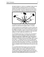
Page 11: ...nd monitoring signals The User Segment consists of the receivers processors and antennas that allow land sea or airborne operators to receive the GPS satellite broadcasts and compute their precise pos...

Page 12: ...or security reasons has included a special mode in the GPS satellite system design which introduces variable timing errors into the satellite signals This mode is known as Selective Availability SA an...

Page 13: ...otters fishfinders radars integrated systems etc which are set up to use these sentences from the NMEA 0183 format Please read through this manual thoroughly before proceeding with the installation an...

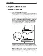
Page 14: ...signal reception In fact the lower the antenna can be mounted and have a clear view to satellites the better The more stable the antenna the easier it is to track satellites lower to the horizon On s...

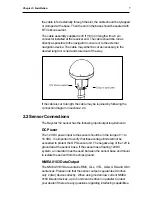
Page 15: ...ast or mount exiting through the mount assembly The aluminium base of your Raystar 112 Sensor has received a chromation treatment which adds toughness resistance to wear and tear and resistance to cor...

Page 16: ...onnections The Raystar 112 sensor has the following input output requirements DC Power The 12 VDC power input to the sensor should be in the range of 11 to 16 VDC It is important to verify that these...

Page 17: ...onnector is plugged directly into the connector labeled GPS on the rear of the display unit cabinet The DC power is then supplied via pins 1 and 2 of the GPS connector to the sensor Other external equ...

Page 18: ...witch or breaker For best noise immunity from other shipboard electronics avoid grouping the GPS sensor power connections together with the radar radio or echo sounder power leads on the same circuit...

Page 19: ...dbook shown in the previous drawing connect the Data wire to terminal 4 of the terminal strip Connect the Data return wire to terminal 3 The shield of the interface cable is also connected to terminal...

Page 20: ...ion information concerning ship s position date and time The time required for obtaining the initial position fix can be reduced to approximately 1 to 3 minutes once the sensor has received this initi...

Page 21: ...S 84 Default GPS datum 1 WGS 72 Loran C 2 BESSEL Japan 3 NAD 27 USA older NOAA charts 4 NAD 27 CAN Canada Alaska 5 EUROPEAN 50 Europe 6 AUSTRAL 66 Australia 7 OSGB 36 UK British Admiralty 8 NAD 83 USA...

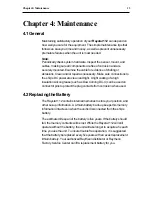
Page 22: ...con grease such as Dow Corning DC 4 can be used on connector pins to protect the plug contacts from corrosion when used 4 2 Replacing the Battery The Raystar 112 contains internal memories to store yo...

Page 23: ...in the unlikely event that a problem arises the following checks should help to locate the possible cause Fault Cause Action No data output after No DC power 1 Check power is switched on 30 min operat...

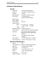
Page 24: ...ial Correction Accepts RTCM SC 104 Geodetic Datum WGS 84 is default 190 others programmable Data Output Single output port NMEA 0183 includes RMC GLL VTG GGA GSA and GSV sentences Data Type TTL level...

Page 25: ...16 RAYSTAR112 InstallationandOperationHandbook...

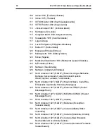
Page 26: ...m 1949 New Zealand 23 Guam 1963 Guam 24 Hayford 1910 Finland 25 Hjorsey 1955 Iceland 26 Indian India and Nepal 27 Ireland 1965 Ireland 28 Kertau 1948 West Malaysia and Singapore 29 L C 5 Astro Cayman...

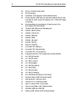
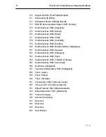
Page 27: ...54 Adindan Senegal 55 Adindan Sudan 56 Afgooye Somalia 57 Ain el Abd 1970 Bahrain 58 Ain el Abd 1970 Saudi Arabia 59 Ain el Abd 1970 Cocos Islands 60 Antigua Island Astro 1943 Antigua and Leeward Isl...

Page 28: ...rabia Syria 89 European 1950 Cyprus 90 European 1950 Egypt 91 European 1950 England Channel Islands Scotland Shetland Islands 92 European 1950 Finland Norway 93 European 1950 Greece 94 European 1950 I...

Page 29: ...Saudi Arabia 126 Nahrwan United Arab Emirates 127 North American 1927 NAD27 Mean for Antigua Barbados Barbuda Caicos Islands Cuba Dominican Republic Grand Cayman Jamaica Turks Islands 128 North Americ...

Page 30: ...n 1936 England Isle of Man Wales 152 Ordnance Survey of Great Britain 1936 Scotland Shetland Islands 153 Ordnance Survey of Great Britain 1936 Wales 154 Pitcairn Astro 1967 Pitcairn Island 155 Point 5...

Page 31: ...outh American 1969 Ecuador Baltra Galapagos 181 South American 1969 Guyana 182 South American 1969 Paraguay 183 South American 1969 Peru 184 South American 1969 Trinidad Tobago 185 South American 1969...

Page 32: ......
Page 33: ...arine Company 676 Island Pond Road Manchester NH 03109 5420 TEL 603 647 7530 FAX 603 634 4756 Raytheon Marine Europe Ltd Anchorage Park Portsmouth Hampshire PO3 5TD England TEL 01705 693611 FAX 01705...

Reviews: