Chapter 3-4
CP33 Chart menu and INFO windows
level range is switched off and the chart changes to a new level of
details.
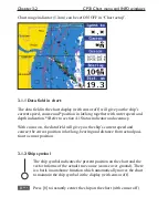
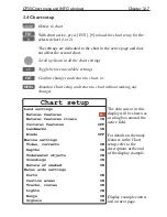
The extended level range can be toggled OFF/ON in chart setup
(default = ON). See section 3.4 Chart setup.
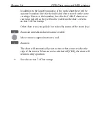
Chart details may not be available in all scales in all areas. Non-
covered areas will be marked as hatched or all blue/white with
coordinate grid (when Grid is set to AUTO (default) in chart setup),
depending on the actual scale - see section 3.4 Chart setup for more
details in regard to what can be shown on the chart and what you
may choose not to have shown.
The
built-in world chart
can be zoomed up/down in six steps, from
a scale of approx. 1:33,000,000 to 1:2,000,000.
An
over-zoom function
enables you to zoom beyond the chart,
which automatically is switched off and replaced by a lat/long coor-
dinate grid. In this mode, the scale can go down to 1:600.
Summary of Contents for CP33
Page 14: ...Chapter 1 8 CP33 Introduction and safety summary ...
Page 44: ...Chapter 3 22 CP33 Chart menu and INFO windows ...
Page 60: ...Chapter 4 16 CP33 Position menu ...
Page 76: ...Chapter 5 16 CP33 Waypoint route menu ...
Page 114: ...Chapter 9 12 CP33 Setup menu Page 1 of 2 Page 2 of 2 ...
Page 118: ...Chapter 10 2 CP33 Installation and service Important settings continued ...
Page 130: ...Chapter 10 14 CP33 Installation and service ...
Page 134: ...Appendix A 4 CP33 Glossary of terms ...
Page 144: ...Appendix C 8 CP33 C MAP attributes ...
Page 149: ...CP33 Chartplotter Index ...


