CP33 Chart menu and INFO windows
Chapter 3-19
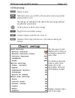
All C-MAP feature groups i.e. Land settings, Marine settings, Naval aids set-
tings and Paper chart settings are described in Appendix C.
To obtain a ‘cleaner’ view of the chart details, you can turn some of the set-
tings OFF if they do not contribute to the clarity of the chart area you wish
to explore. All the listed objects that can be turned on and off speaks for
themselves - they are either ‘on=shown on the chart’ or ‘off=not shown on the
chart’.
All user data in the CP33 system are listed under ‘Chart settings’ in the dis-
play example and are described below:
Chart
can be set to NORMAL, COMPRESSED or CHART OFF:
NORMAL - (default) will automatically select the chart level appropriate for
the selected range/scale.
COMPRESSED - will change the range (scale) / chart level ratio one step,
which, depending on the actual chart, will select a more detailed level.
CHART OFF - will only show all the user-made data such as waypoints,
routes, lines and tracks etc.
Landfilling
- default=ON. When set to Off there will be no special color to
indicate where there is land i.e. land will be all blue.
Boundary lines
(default=ON) will indicate available C-MAP chart areas.
Mixing levels
(default =OFF) when set to ON you will no longer see any
blank chart areas, as the C-MAP library will find the missing area in a differ-
ent level to cover the blank area otherwise left on the screen. However, when
using this feature, chart re-draw time will be increased a little.
Marine presentation
can be set to INTERNATIONAL or AMERICAN:
INTERNATIONAL - (default) will present NavAids in ‘real life’ shapes and
colors for quick visual recognition (as per official INT1 standard paper chart
presentation).
AMERICAN - will present NavAids in simplified shapes and real colors (as
generally found on NOAA paper charts).
Simplified draw mode
(default=OFF) - when set to ON the NavAids will be
shown in generic symbols for minimum visual clutter on-screen.
Quick chart info
(default=ON) - placing the chart cursor on a C-MAP object
will activate a small info window with details on the object. Info window will
automatically close after 10 seconds or when cursor is moved away.
Summary of Contents for CP33
Page 14: ...Chapter 1 8 CP33 Introduction and safety summary ...
Page 44: ...Chapter 3 22 CP33 Chart menu and INFO windows ...
Page 60: ...Chapter 4 16 CP33 Position menu ...
Page 76: ...Chapter 5 16 CP33 Waypoint route menu ...
Page 114: ...Chapter 9 12 CP33 Setup menu Page 1 of 2 Page 2 of 2 ...
Page 118: ...Chapter 10 2 CP33 Installation and service Important settings continued ...
Page 130: ...Chapter 10 14 CP33 Installation and service ...
Page 134: ...Appendix A 4 CP33 Glossary of terms ...
Page 144: ...Appendix C 8 CP33 C MAP attributes ...
Page 149: ...CP33 Chartplotter Index ...

