

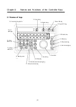


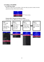

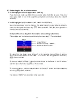
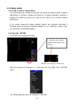


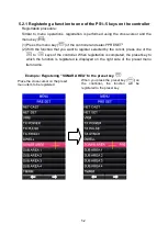

3-2
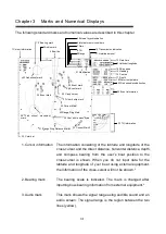
4. Bow line
This line shows the direction in which the ship is going (light blue).
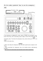
5. External synchronization
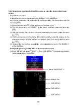
The external synchronization mode is activated by menu
selection in the order of "MENU
”–“TX”–“TX SYNCRO”–
“EXTERNAL." The mode is indicated as “EXT” on the screen.
6. Internal Memory Number
This field shows the memory number with which the settings
being currently used are stored. The standard value is
indicated as
“STD” in red.
7. Gain
This field shows the gain of the sonar image that is currently
in use.
8. Tilt
This
field
shows
the
tilt
of
the
directional
transmission/reception beam that is currently in use.
9. Range
This field shows the range of the sonar image that is currently
in use. The range is interlocked with an off-center value.
10. Transmission indication
The
mark is displayed during transmission.
11. Hoisting amount
The projection amount of the hoisting device is indicated.
12. Date/time
The current date and time is shown.
13. Latitude/longitude The latitude and longitude of the
user’s ship is shown. If
latitude/longitude information is not input from external
equipment, it will not be displayed.*
14. Ship speed
The
user’s ship speed information is shown. If the speed
information of the
user’s ship is not input from external
equipment, it will not be displayed.*
Summary of Contents for SCS-60
Page 1: ...Model SCS 60 Scanning Sonar Operation Manual Ver 5 00E Rev 0...
Page 2: ...MEMO...
Page 12: ...x MEMO...
Page 16: ...1 4 MEMO...
Page 32: ...4 6 MEMO...
Page 50: ...5 18 MEMO...
Page 70: ...6 20 MEMO...
Page 86: ...7 16 MEMO...
Page 94: ...8 8 MEMO...


