


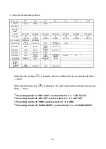

3-3
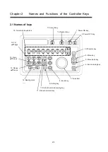
15. Heading
The ship heading information is shown. If heading information
is not input from external equipment, it will not be displayed.*
16. Course
The course of the
user’s ship is shown. If course information
is not input from external equipment, it will not be displayed.*
17. Depth
The water depth information is shown. If water depth
information is not input from external equipment, it will not be
displayed.*
18. Water temperature The water temperature is shown. If water temperature
information is not input from external equipment, it will not be
displayed.*
19. Wind speed/wind direction
The wind speed and wind direction are shown. If the wind
speed and wind direction information is not input from external
equipment, it will not be displayed.*
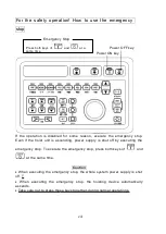
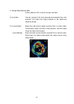
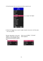
20. Event Information The information of the event mark
is shown. You can select
event information from "Relative"; "Deviation"; and
“Latitude/longitude.”
"Relative" shows the horizontal distance, depth, and compass
bearing.
"Deviation" shows the deviation distance and deviation speed.
"Latitude/longitude" shows that of the event mark.
If
“Latitude/longitude” is set with the latitude and longitude
information of the
user’s ship not being input from external
equipment,
“Latitude/longitude” will not be displayed.*
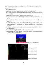
21. Stabilization
This function reduces the influence of ship wavering on the
screen as caused by the shaking of the ship. The stabilization
mode is activated by menu selection in the order of "MENU
” –
“SUB SCREEN” – “STABILIZATION” – “ON."
Summary of Contents for SCS-60
Page 1: ...Model SCS 60 Scanning Sonar Operation Manual Ver 5 00E Rev 0...
Page 2: ...MEMO...
Page 12: ...x MEMO...
Page 16: ...1 4 MEMO...
Page 32: ...4 6 MEMO...
Page 50: ...5 18 MEMO...
Page 70: ...6 20 MEMO...
Page 86: ...7 16 MEMO...
Page 94: ...8 8 MEMO...


