
11
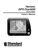
Horizon GPS Chart400 User Manual
mode and “search” the sky for satellites. This is fully automatic and requires no user intervention.
This process can take several minutes. The TFF is also influenced by the current satellite geometry
and position of the antenna. The antenna must have an unobstructed view of the sky. See the separate
antenna installation guide for more details.
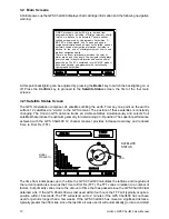
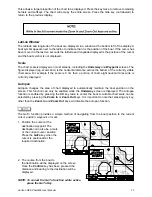
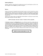
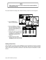
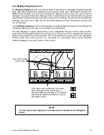
The Satellite Status screen displays the signal strengths of the visible satellites and their current
positions. Signal strength is displayed in bar graph form, displaying the signal levels of the seven
strongest satellites. Satellite position is displayed within two concentric circles. The outer circle
indicates zero degrees elevation (the horizon), the inner circle indicates 45° elevation and the center
of the circles indicate 90° (directly above). If the GPS Chart400 is moving the current Course Over
Ground (COG) will also be displayed (if enabled).
The geometric quality (HDOP) and date/time are also displayed. A low HDOP indicates a more
precise fix. A higher HDOP indicates a less accurate fix. The USA Department of Defence (DoD)
introduces a varying offset, known as Selective Availability (SA), to degrade the accuracy of the
GPS system. As an approximate guideline it is generally assumed that the accuracy obtained with
SA active causes the GPS derived position to be within 100 yards of the true position 90% of the time
and within 50 yards of the true position 50% of the time. For increased accuracy some countries
provide Differential GPS (DGPS) networks to increase accuracy to within a few yards.
Mapshift and Datums
Satellite derived positions are based on a worldwide reference (datum) known as WGS 1984. Many
paper charts are based on datums other than WGS 1984. This results in an offset between a Lat/Lon
plotted on the paper chart and the same Lat/Lon plotted on the GPS Chart400. To match the GPS
Chart400 with your local charts you must enter the datum for your local area, see section 7 for a list
of available datums. Once your local datum has been entered all latitudes and longitudes, including
waypoints, will match the paper charts. See section 3.3 for details on how to access the datum menu.
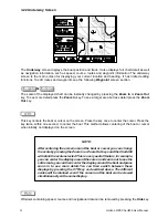
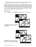
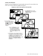
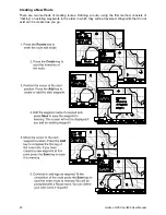
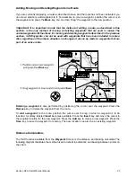
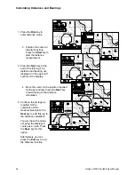
If you prefer to retain the WGS84 datum (no local datum) but find that the boat position is offset you
can correct this offset with the Mapshift function. To use the mapshift function first locate your boat
at a known point on the chart and select a scale (Zoom In, Zoom Out) similar to the paper chart. From
the Satellite Status screen press the Mapshift key. Use the cursor keys to move the cursor to the
correct location for the boat. Press the Set key to select the new location. Press the Done key to
save to memory. The Mapshift offset is displayed on screen in the Waypoint data window. Verify the
setting by performing the same procedure at other known locations.
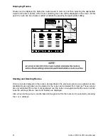
NOTE:
The mapshift function provides a method for eliminating minor offsets. It can
not be used to correct Lat/Lon values to match local charts. After mapshift is
applied all Lat/Lon values remain in the WGS84 datum.