28
Horizon GPS Chart400 User Manual
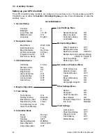
3. CDI/Units/Alarms
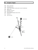
CDI Scale
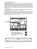
The Course Deviation Indicator (CDI) is displayed on the BirdsEye
Highway screen. It is a graphical indication of the cross track error
(XTE), indicating the magnitude of the course adjustment required to
return to the original track. See section 6.0 for a description of XTE.
Available scale options are available 0.5, 1.0, 2.0, 4.0, 10.0 distance
units.
Distance Units
Available options are Nautical miles, statute miles or kilometers.
Speed Units
Available options are Knots, miles per hour and kilometers per hour.
Depth Units.
Available options are Feet, fathoms or meters.
Alarm Activated
The chart plotter’s alarms (Arrival alarm, Anchor Alarm and Guard Zone)
can be selected on or off. The alarm values remain in memory when the
alarms are selected off and become active again when the alarms are
enabled.
Arrival Radius
An alarm will sound (if active) when your boat comes within a set
distance of a waypoint. If a route is active the GPS Chart400 will
automatically start navigating to the next waypoint in the route. This
radius can be set anywhere from OFF to 9.99 distance units, in 0.01
steps. The same setting is used for Danger waypoints.
Note: The arrival alarm is also activated when the waypoint passes
abeam of the boat, while the boat is outside the arrival circle. This
results in the alarm being triggered when you go past the waypoint
without entering the arrival circle.
Anchor Alarm
Setting an anchor alarm value will enable the anchor watch function. The
GPS Chart400 will save the current boat position and sound the alarm
whenever the distance from this point to the boat’s current position
exceeds the value chosen. This radius can be set anywhere from OFF to
9.99 distance units, in 0.01 steps. The Anchor Alarm function is intended
for differential GPS operation, where the error introduced by Selective
Availability (SA) has been significantly reduced.
Guard Zone
Guard Zone is a cross track error (XTE) alarm. The alarm is sounded
when the distance from the boat to the intended track (XTE) exceeds the
Guard Zone value. This distance can be set anywhere from OFF to 9.99
distance units, in 0.01 steps.
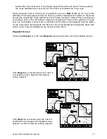
4. Map Configuration
The Map Configuration screen provides access to five sub menus allowing you to enable or
disable an extensive range of chart features. You can configure a display format that best suits
your needs. Some important points to note are:
Plotter Mode. Occasionally it is desirable to Zoom In to a range that exceeds the chart information
in the cartridge. An example of this is if you wish to track very small movements of the boat, or
are using the GPS Chart400 in an area where detailed C-MAP charts are unavailable. To enable
plotter mode you must set Plotter Mode to ON in the Other Settings Menu. In this situation, when
you Zoom In beyond the chart limits the GPS Chart400 will enter track plot mode and will only
display the boat position and track (if enabled). Chart and map information will no longer be
displayed.
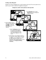
Bathometric Lines and soundings. The C-MAP cartridges contain a large amount of depth data
in the form of spot soundings and bathometric lines (depth contours). These can be selectively
displayed. The Bathometric & Soundings Range setting allows the user to set the range in which
spot soundings and bathometric lines are displayed. Also, the maximum depth to which shallow
water patterns are displayed can be set by changing the Depth Area Limits setting. All these
functions are available from the Marine Settings Menu.